IMAGES TAKEN NEAR TO
Foulds Road, LOUGHBOROUGH, LE12 7ZG
Introduction
This page details the photographs taken nearby to Foulds Road, LE12 7ZG by members of the Geograph project.
The Geograph project started in 2005 with the aim of publishing, organising and preserving representative images for every square kilometre of Great Britain, Ireland and the Isle of Man.

There are currently over 7.5m images from over14,400 individuals and you can help contribute to the project by visiting https://www.geograph.org.uk
Image Map (Loading...)


Getting Data...Please wait
Leaflet Map data © OpenStreetMap
Images are licensed for reuse under creativecommons.org/licenses/by-sa/2.0
Notes
- Clicking on the map will re-center to the selected point.
- The higher the marker number, the further away the image location is from the centre of the postcode.
Image Listing (6 Images Found)
Images are licensed for reuse under creativecommons.org/licenses/by-sa/2.0
Image
Details
Distance
1
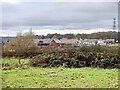
New house building on the edge of Mountsorrel
Image: © Ian Calderwood
Taken: 3 Dec 2022
0.03 miles
2
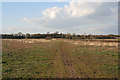
Rough Farmland at Mountsorrel
Looking from Halstead Road to Broad Hill. The Leicestershire Round Long Distance Path follows the base of foot hill
Image: © Kate Jewell
Taken: 10 Apr 2006
0.04 miles
3
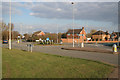
Roundabout on Halstead Road, Mountsorrel
There is a great deal of new housing in Mountsorrel, transforming it from a sleepy village to a busy commuter area, handy for Leicester and Loughborough. This estate is built on Walton Way to the south west of the village.
Image: © Kate Jewell
Taken: 10 Apr 2006
0.18 miles

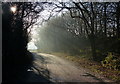
6
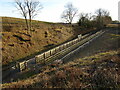
Mountsorrel Station
The end of a short branch of the Great Central Railway.
Image: © Jonathan Thacker
Taken: 19 Feb 2023
0.24 miles