IMAGES TAKEN NEAR TO
Baum Drive, LOUGHBOROUGH, LE12 7WW
Introduction
This page details the photographs taken nearby to Baum Drive, LE12 7WW by members of the Geograph project.
The Geograph project started in 2005 with the aim of publishing, organising and preserving representative images for every square kilometre of Great Britain, Ireland and the Isle of Man.

There are currently over 7.5m images from over14,400 individuals and you can help contribute to the project by visiting https://www.geograph.org.uk
Image Map (Loading...)


Getting Data...Please wait
Leaflet Map data © OpenStreetMap
Images are licensed for reuse under creativecommons.org/licenses/by-sa/2.0
Notes
- Clicking on the map will re-center to the selected point.
- The higher the marker number, the further away the image location is from the centre of the postcode.
Image Listing (4 Images Found)
Images are licensed for reuse under creativecommons.org/licenses/by-sa/2.0
Image
Details
Distance
1
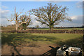
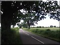
Farmland near Mountsorrel, Leicestershire
West Cross Lane follows the line of the hedge across the centre of the photograph.
Image: © Kate Jewell
Taken: 10 Apr 2006
0.08 miles
2
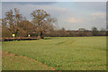
Winter Wheat near Mountsorrel
This field of winter wheat is growing strongly next to West Cross Lane. Modern houses in Mountsorrel are just behind the trees.
Image: © Kate Jewell
Taken: 10 Apr 2006
0.08 miles
3
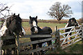
Horses on West Cross Lane, near Mountsorrel
Three curious ponies.
Image: © Kate Jewell
Taken: 10 Apr 2006
0.08 miles