IMAGES TAKEN NEAR TO
The Banks, LOUGHBOROUGH, LE12 7RD
Introduction
This page details the photographs taken nearby to The Banks, LE12 7RD by members of the Geograph project.
The Geograph project started in 2005 with the aim of publishing, organising and preserving representative images for every square kilometre of Great Britain, Ireland and the Isle of Man.

There are currently over 7.5m images from over14,400 individuals and you can help contribute to the project by visiting https://www.geograph.org.uk
Image Map (Loading...)


Getting Data...Please wait
Leaflet Map data © OpenStreetMap
Images are licensed for reuse under creativecommons.org/licenses/by-sa/2.0
Notes
- Clicking on the map will re-center to the selected point.
- The higher the marker number, the further away the image location is from the centre of the postcode.
Image Listing (69 Images Found)
Images are licensed for reuse under creativecommons.org/licenses/by-sa/2.0
Image
Details
Distance
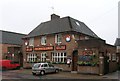
1
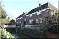
Houses in Sileby
Alongside Sileby Brook. Houses probably date from 1934.
Image: © Andrew Abbott
Taken: 8 Feb 2020
0.02 miles
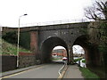
2
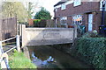
Bridge over Sileby Brook
Built in 1934.
Image: © Andrew Abbott
Taken: 8 Feb 2020
0.02 miles
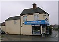
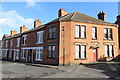
4
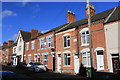
Swan Street Villas
Swan Street Villas from 1878 and next door Stanley House of 1890.
Image: © Andrew Abbott
Taken: 8 Feb 2020
0.07 miles
6
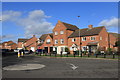
Houses on Burton Road, Sileby
At the junction with Brook Street and The Banks.
Image: © Andrew Abbott
Taken: 8 Feb 2020
0.08 miles
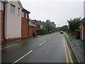
9
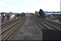
Midland Main Line, Sileby
Looking south from platform 2 of Sileby railway station.
Image: © Andrew Abbott
Taken: 8 Feb 2020
0.14 miles