IMAGES TAKEN NEAR TO
Ratcliffe Road, LOUGHBOROUGH, LE12 7PY
Introduction
This page details the photographs taken nearby to Ratcliffe Road, LE12 7PY by members of the Geograph project.
The Geograph project started in 2005 with the aim of publishing, organising and preserving representative images for every square kilometre of Great Britain, Ireland and the Isle of Man.

There are currently over 7.5m images from over14,400 individuals and you can help contribute to the project by visiting https://www.geograph.org.uk
Image Map (Loading...)


Getting Data...Please wait
Leaflet Map data © OpenStreetMap
Images are licensed for reuse under creativecommons.org/licenses/by-sa/2.0
Notes
- Clicking on the map will re-center to the selected point.
- The higher the marker number, the further away the image location is from the centre of the postcode.
Image Listing (8 Images Found)
Images are licensed for reuse under creativecommons.org/licenses/by-sa/2.0
Image
Details
Distance


4
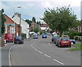
Ratcliffe Road in Sileby, Leicestershire
Image: © Mat Fascione
Taken: 15 Jun 2008
0.19 miles
5
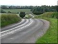
Ratcliffe Road descends towards Sileby
Image: © Mat Fascione
Taken: 15 Jun 2008
0.20 miles
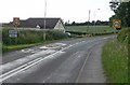
7
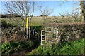
On the footpath from Ratcliffe on the Wreake to Sileby
Crossing a tributary stream of the River Soar
Image: © Tim Heaton
Taken: 2 Dec 2021
0.21 miles