IMAGES TAKEN NEAR TO
Finsbury Avenue, LOUGHBOROUGH, LE12 7PJ
Introduction
This page details the photographs taken nearby to Finsbury Avenue, LE12 7PJ by members of the Geograph project.
The Geograph project started in 2005 with the aim of publishing, organising and preserving representative images for every square kilometre of Great Britain, Ireland and the Isle of Man.

There are currently over 7.5m images from over14,400 individuals and you can help contribute to the project by visiting https://www.geograph.org.uk
Image Map (Loading...)


Getting Data...Please wait
Leaflet Map data © OpenStreetMap
Images are licensed for reuse under creativecommons.org/licenses/by-sa/2.0
Notes
- Clicking on the map will re-center to the selected point.
- The higher the marker number, the further away the image location is from the centre of the postcode.
Image Listing (6 Images Found)
Images are licensed for reuse under creativecommons.org/licenses/by-sa/2.0
Image
Details
Distance

2
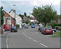
Ratcliffe Road in Sileby, Leicestershire
Image: © Mat Fascione
Taken: 15 Jun 2008
0.09 miles


5

Ainsworth Drive, off Stanage Road, Sileby
Image: © Dave Thompson
Taken: 20 May 2020
0.12 miles
6

Farmland at Sileby
Looking SE across the square from the footpath, Highgate Lodge in the distance.
Image: © Kate Jewell
Taken: 4 Mar 2006
0.24 miles