IMAGES TAKEN NEAR TO
Pawdy Lane, LOUGHBOROUGH, LE12 7GY
Introduction
This page details the photographs taken nearby to Pawdy Lane, LE12 7GY by members of the Geograph project.
The Geograph project started in 2005 with the aim of publishing, organising and preserving representative images for every square kilometre of Great Britain, Ireland and the Isle of Man.

There are currently over 7.5m images from over14,400 individuals and you can help contribute to the project by visiting https://www.geograph.org.uk
Image Map (Loading...)


Getting Data...Please wait
Leaflet Map data © OpenStreetMap
Images are licensed for reuse under creativecommons.org/licenses/by-sa/2.0
Notes
- Clicking on the map will re-center to the selected point.
- The higher the marker number, the further away the image location is from the centre of the postcode.
Image Listing (7 Images Found)
Images are licensed for reuse under creativecommons.org/licenses/by-sa/2.0
Image
Details
Distance
1
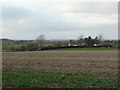
North Farm
Farming landscape on Seagrave Wolds.
Image: © Alan Murray-Rust
Taken: 25 Nov 2011
0.03 miles
2
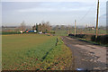
North Farm, Paudy Lane
Looking north from Paudy Lane (120 metres above sea level) you can see Image on the horizon.
Image: © Kate Jewell
Taken: 29 Mar 2006
0.05 miles
3
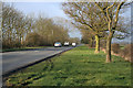
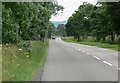
Paudy Lane near Seagrave, Leicestershire
Looking south west towards Paudy Cross Roads
Image: © Kate Jewell
Taken: 29 Mar 2006
0.05 miles

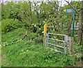
7
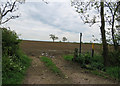
Entrance to a field and footpath
The footpath goes to Seagrave.
Image: © Andrew Tatlow
Taken: 19 May 2016
0.23 miles