IMAGES TAKEN NEAR TO
Clover Lane, LOUGHBOROUGH, LE12 7FE
Introduction
This page details the photographs taken nearby to Clover Lane, LE12 7FE by members of the Geograph project.
The Geograph project started in 2005 with the aim of publishing, organising and preserving representative images for every square kilometre of Great Britain, Ireland and the Isle of Man.

There are currently over 7.5m images from over14,400 individuals and you can help contribute to the project by visiting https://www.geograph.org.uk
Image Map (Loading...)


Getting Data...Please wait
Leaflet Map data © OpenStreetMap
Images are licensed for reuse under creativecommons.org/licenses/by-sa/2.0
Notes
- Clicking on the map will re-center to the selected point.
- The higher the marker number, the further away the image location is from the centre of the postcode.
Image Listing (14 Images Found)
Images are licensed for reuse under creativecommons.org/licenses/by-sa/2.0
Image
Details
Distance
1
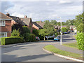
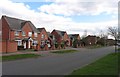
Rowe Leyes Furlong
Modern housing development on the south-eastern edge of Mountsorrel.
Image: © Alan Murray-Rust
Taken: 8 Sep 2013
0.08 miles
2
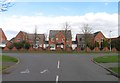
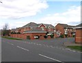
Kingfisher Road/Speedwell Road Junction
Image: © Andrew Tatlow
Taken: 19 Mar 2012
0.13 miles
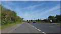
3
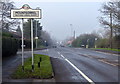
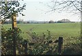
Leicester Road in Mountsorrel
The sign is near the junction with Linkfield Road.
Image: © Mat Fascione
Taken: 4 Jan 2015
0.14 miles
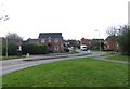
6
Kingfisher Road/Mallard Road Junction
Image: © Andrew Tatlow
Taken: 19 Mar 2012
0.17 miles
8
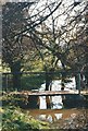
The Leicestershire Round crosses this clapper bridge
Image: © Tim Glover
Taken: 28 Oct 1994
0.18 miles
10
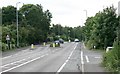
On the A6
The busy A6 heading north.
Image: © Peter Mackenzie
Taken: 14 May 2019
0.18 miles