IMAGES TAKEN NEAR TO
Loughborough Road, LOUGHBOROUGH, LE12 7AR
Introduction
This page details the photographs taken nearby to Loughborough Road, LE12 7AR by members of the Geograph project.
The Geograph project started in 2005 with the aim of publishing, organising and preserving representative images for every square kilometre of Great Britain, Ireland and the Isle of Man.

There are currently over 7.5m images from over14,400 individuals and you can help contribute to the project by visiting https://www.geograph.org.uk
Image Map (Loading...)


Getting Data...Please wait
Leaflet Map data © OpenStreetMap
Images are licensed for reuse under creativecommons.org/licenses/by-sa/2.0
Notes
- Clicking on the map will re-center to the selected point.
- The higher the marker number, the further away the image location is from the centre of the postcode.
Image Listing (55 Images Found)
Images are licensed for reuse under creativecommons.org/licenses/by-sa/2.0
Image
Details
Distance
1

The Waterside, Mountsorrel
A new housing development off Loughborough Road in Mountsorrel, Leicestershire.
Image: © Mat Fascione
Taken: 31 Jul 2007
0.04 miles
2
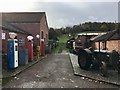
Stonehurst Farm
Old petrol pumps and tractors.
Image: © John H Darch
Taken: 10 Nov 2018
0.07 miles
3

Waterside Drive and Wishbone Lane, Mountsorrel
From the River Soar.
Image: © Andrew Abbott
Taken: 8 Feb 2020
0.08 miles
4

The Quay, Mountsorrel
"Waterside is a private development around Mount Sorrel Staithe, a 32-berth inland harbour in Leicestershire, built in the style of a traditional 19th Century Dutch village ... " [Buildingtalk.com]
Image: © Tim Heaton
Taken: 25 Jun 2020
0.09 miles
5

The Quay, Mountsorrel
From the River Soar.
Image: © Andrew Abbott
Taken: 8 Feb 2020
0.09 miles
6

T A Walker Limited
A trucking company based in Mountsorrel.
Image: © Andrew Abbott
Taken: 8 Feb 2020
0.10 miles
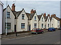
7
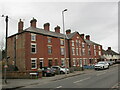
Terraced housing, Loughborough Road, North End
Image: © Jonathan Thacker
Taken: 12 Mar 2023
0.11 miles
8
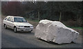
Large rock at Mountsorrel
This is the access road to the roadstone quarry at Mountsorrel.
Image: © Terry Roberts
Taken: 1 Apr 2005
0.11 miles
9
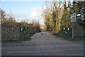
Entrance to Industrial Estate near Quorn
This gateway is opposite the Lafarge Quarry in Image
Image: © Kate Jewell
Taken: 10 Apr 2006
0.11 miles
10
Castledine almshouses
Now run by a charitable organisation to provide sheltered housing for local ladies ('of good character'), these 6 almshouses were originally built in 1853 'to house spinsters of the village' on the proceeds of a bequest by Anne Castledine. They were extensively refurbished in 2007 and reopened soon after.
Image: © Richard Law
Taken: 7 May 2015
0.11 miles