IMAGES TAKEN NEAR TO
Loughborough Road, LOUGHBOROUGH, LE12 7AP
Introduction
This page details the photographs taken nearby to Loughborough Road, LE12 7AP by members of the Geograph project.
The Geograph project started in 2005 with the aim of publishing, organising and preserving representative images for every square kilometre of Great Britain, Ireland and the Isle of Man.

There are currently over 7.5m images from over14,400 individuals and you can help contribute to the project by visiting https://www.geograph.org.uk
Image Map (Loading...)


Getting Data...Please wait
Leaflet Map data © OpenStreetMap
Images are licensed for reuse under creativecommons.org/licenses/by-sa/2.0
Notes
- Clicking on the map will re-center to the selected point.
- The higher the marker number, the further away the image location is from the centre of the postcode.
Image Listing (125 Images Found)
Images are licensed for reuse under creativecommons.org/licenses/by-sa/2.0
Image
Details
Distance
1
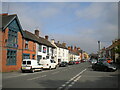
Loughborough Road, Mountsorrel
Looking towards the centre of the village.
Image: © Richard Vince
Taken: 13 May 2023
0.03 miles
2
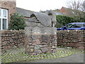
Swan sculpture, Mountsorrel
The work of Michael Grevatte https://artuk.org/discover/artists/grevatte-michael-b-1943 1993. For another of his works see Image
Image: © Jonathan Thacker
Taken: 5 Mar 2022
0.05 miles
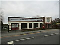
3
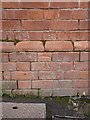
OS benchmark - Mountsorrel, former railway building
An OS cutmark on the frontage of a warehouse which looks like it was associated with the former railway from Barrow on Soar into the quarries. Originally levelled at 44.775m above Ordnance Datum Newlyn.
Image: © Richard Law
Taken: 7 May 2015
0.05 miles
4
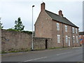
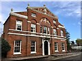
9 Loughborough Road, Mountsorrel
No 9, once The Crown Inn, and its attached walls which were Grade II listed https://britishlistedbuildings.co.uk/101228136-numbers-9-and-9a-and-wall-mountsorrel#.XZ5AwUZKjIU & https://historicengland.org.uk/listing/the-list/list-entry/1228136 in 1984. The house itself is mid 18th century.
Image: © Richard Law
Taken: 14 Aug 2019
0.06 miles
5
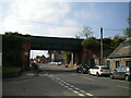
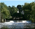
Bridge across Loughborough Road, Mountsorrel
A former railway bridge that gave access to a quarry, now carrying a conveyor that performs the same function.
Image: © Richard Vince
Taken: 13 May 2023
0.06 miles
7
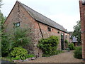
Barn conversion at rear of No 9 Loughborough Road
Probably 18th century with a 19th century brick-built raising of the eaves, and a late 20th century conversion to a house. Grade II listed https://britishlistedbuildings.co.uk/101228114-barn-at-and-directly-to-rear-of-numbers-9-and-9a-mountsorrel#.XZ5CI0ZKjIU & https://historicengland.org.uk/listing/the-list/list-entry/1228114 in 1984.
Image: © Richard Law
Taken: 14 Aug 2019
0.06 miles
8
Charnwood and Highmeres. Mountsorrel
Image: © Jonathan Thacker
Taken: 5 Mar 2022
0.06 miles