1
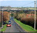
Looking down Kirk Ley Road
Looking across the village of East Leake with the gypsum works in the distance.
Image: © Alan Murray-Rust
Taken: 15 May 2014
0.07 miles
2
Paddock east of Kirk Ley Road
Inhabited by two horses.
Image: © Jonathan Billinger
Taken: 13 Jun 2008
0.07 miles
3
Kirk Ley Road, East Leake
Image: © Richard Vince
Taken: 18 Apr 2014
0.07 miles
4
Snow on the Wolds ? 1979
A South Notts bus heads towards Nottingham after the heavy snowfall in February 1979. Services had been seriously disrupted until roads were ploughed clear. This is one of a series of views featuring buses in the 60s, 70s, and 80s. http://www.geograph.org.uk/search.php?i=137652761
Image: © Alan Murray-Rust
Taken: 7 Feb 1979
0.08 miles
5
Top of Kirk Ley Road, East Leake
The southernmost point in East Leake village, where Kirk Ley Road meets Rempstone Road.
Image: © Richard Vince
Taken: 18 Apr 2014
0.08 miles
6
Rempstone Road in the snow
The snowfall in 1979 was significantly heavier than what was seen as exceptional in 2009. This was taken a couple of days after the occurrence when bus services had been reestablished after ploughing.
This is one of a series of views featuring buses in the 60s, 70s, and 80s. http://www.geograph.org.uk/search.php?i=2114547&displayclass=slide
Image: © Alan Murray-Rust
Taken: 16 Feb 1979
0.08 miles
7
East Leake, Notts
The southern end of Kirk Ley Road. Buses providing the Loughborough-Nottingham service use this road on the Melton Road (the A6006)- East Leake section.
Image: © David Hallam-Jones
Taken: 9 Nov 2014
0.09 miles
8
Fingerpost, Rempstone Road/Kirk Ley Road
Notts C C octagonal concrete post with slotted arms and octagonal cast-iron finial. There has been some fiddling with letters - Elton should be Melton, and Ash should be Ashby.
Image: © Alan Murray-Rust
Taken: 15 May 2014
0.09 miles
9
Signpost, Rempstone Road
At the top of Kirk Ley Road.
A good example of a traditional Nottinghamshire fingerpost, with octagonal concrete upright and the cast iron NOTTS C.C. finial. The through fingers with the pointed ends are relatively new, and would have originally matched the East Leake finger, with square ends and distances.
Image: © Alan Murray-Rust
Taken: 3 Feb 2009
0.10 miles
10
Rempstone Road, East Leake
Skirting the southern edge of the village, with farmland beyond the hedge on the left.
Image: © Richard Vince
Taken: 18 Apr 2014
0.12 miles


