IMAGES TAKEN NEAR TO
Brook Farm Court, LOUGHBOROUGH, LE12 6SL
Introduction
This page details the photographs taken nearby to Brook Farm Court, LE12 6SL by members of the Geograph project.
The Geograph project started in 2005 with the aim of publishing, organising and preserving representative images for every square kilometre of Great Britain, Ireland and the Isle of Man.

There are currently over 7.5m images from over14,400 individuals and you can help contribute to the project by visiting https://www.geograph.org.uk
Image Map (Loading...)


Getting Data...Please wait
Leaflet Map data © OpenStreetMap
Images are licensed for reuse under creativecommons.org/licenses/by-sa/2.0
Notes
- Clicking on the map will re-center to the selected point.
- The higher the marker number, the further away the image location is from the centre of the postcode.
Image Listing (103 Images Found)
Images are licensed for reuse under creativecommons.org/licenses/by-sa/2.0
Image
Details
Distance
1
Willoughby-on-the-Wolds
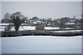
Snowy view from Back Lane to Willoughby-on-the-Wolds
Image: © Richard Croft
Taken: 22 Jan 2013
0.02 miles
2
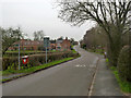
Main Street, Willoughby
Looking west towards West Thorpe. The name element Thorp(e) is typically of Danish origin and refers to a subsidiary settlement of an established village, clearly the case here.
Image: © Alan Murray-Rust
Taken: 24 Jan 2014
0.02 miles
3
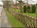
New laid hedge
The owner of the property is to be commended for having the garden hedge laid in traditional style.
Image: © Alan Murray-Rust
Taken: 24 Jan 2014
0.03 miles
4
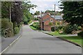
Main Street in Willoughby-on-the-Wolds
A village in south Nottinghamshire.
Image: © Mat Fascione
Taken: 13 Jul 2008
0.03 miles
5
Willoughby-on-the-Wolds, South Nottinghamshire
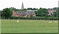
The spire belongs to St. Mary & All Saints' Church, the modern houses are on Brook Farm Court.
Image: © Mat Fascione
Taken: 13 Jul 2008
0.05 miles
6
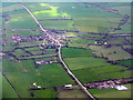
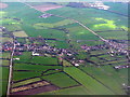
Willoughby-on-the-Wolds
An aerial view, looking south. The obvious north/south road is Willoughby Road.
Image: © M J Richardson
Taken: 5 Apr 2016
0.06 miles
7
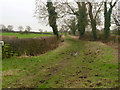
Green Lane, Willoughby
One of a couple of byways which run between Main Street and Back Lane.
Image: © Alan Murray-Rust
Taken: 24 Jan 2014
0.07 miles
9
Willoughby-on-the-Wolds
A view from the north - on the map a large area called 'Nottinghamshire Woods'. The Lakeside Fishing Centre Image is visible at top right.
Image: © M J Richardson
Taken: 5 Apr 2016
0.08 miles
10
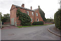
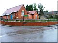
Brook House, Main Street, Willoughby-on-the-Wolds
Image: © Ian S
Taken: 31 Aug 2020
0.09 miles