IMAGES TAKEN NEAR TO
Quince Close, LOUGHBOROUGH, LE12 6RB
Introduction
This page details the photographs taken nearby to Quince Close, LE12 6RB by members of the Geograph project.
The Geograph project started in 2005 with the aim of publishing, organising and preserving representative images for every square kilometre of Great Britain, Ireland and the Isle of Man.

There are currently over 7.5m images from over14,400 individuals and you can help contribute to the project by visiting https://www.geograph.org.uk
Image Map (Loading...)


Getting Data...Please wait
Leaflet Map data © OpenStreetMap
Images are licensed for reuse under creativecommons.org/licenses/by-sa/2.0
Notes
- Clicking on the map will re-center to the selected point.
- The higher the marker number, the further away the image location is from the centre of the postcode.
Image Listing (15 Images Found)
Images are licensed for reuse under creativecommons.org/licenses/by-sa/2.0
Image
Details
Distance
1
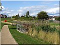
Balancing pond and footbridge
Flood management for a new housing development.
Image: © Ian Calderwood
Taken: 25 Aug 2018
0.07 miles
2
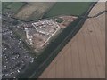
New Housing Development at East Leake
Image: © Anthony Parkes
Taken: 3 Aug 2015
0.07 miles
3
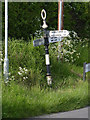
Fingerpost, Woodgate Road/Rempstone Road
Notts C C traditional cast-iron with annulus finial.
Image: © Alan Murray-Rust
Taken: 15 May 2014
0.09 miles
4
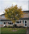
A Maple on Sycamore Road
A typical domestic scene for this square
Image: © Chris J Dixon
Taken: 11 Oct 2001
0.11 miles
5
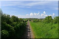
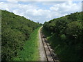
The Great Central Railway line heading along the west side of East Leake
This is part of the northern, Loughborough to Ruddington (south Nottingham) section of the heritage line, with plans to rejoin it to the southern part https://www.gcrailway.co.uk/unify/ .
Image: © Tim Heaton
Taken: 5 May 2024
0.16 miles
7
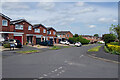
Sycamore Road, East Leake
East Leake is a village that grew rapidly in the second half of the 20th century and continues to do so; the population at the 2011 census was 6,337. The houses here, built around 1970, are typical of much of the housing stock to the south-west of the village centre.
Image: © Stephen McKay
Taken: 13 May 2022
0.19 miles
8
A corner of East Leake
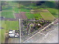
A triangle of what looks like 1930s housing, with long gardens on the edge of the village, bounded by Rempstone Road, Woodgate Road and Kirk Ley Road, and penetrated by Bley Avenue. The glasshouses and polytunnels are a nursery and microprogation laboratory supplying the garden trade in the UK and Europe http://www.micropropagation-services.co.uk/page2.html
Image: © M J Richardson
Taken: 5 Apr 2016
0.21 miles
9
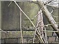
Benchmark on Woodgate Road bridge East Leake
Ordnance Survey Benchmark on Great Central Railway bridge 313
Image: © John Beniston
Taken: 16 Mar 2021
0.22 miles