IMAGES TAKEN NEAR TO
Kirk Ley Road, LOUGHBOROUGH, LE12 6PE
Introduction
This page details the photographs taken nearby to Kirk Ley Road, LE12 6PE by members of the Geograph project.
The Geograph project started in 2005 with the aim of publishing, organising and preserving representative images for every square kilometre of Great Britain, Ireland and the Isle of Man.

There are currently over 7.5m images from over14,400 individuals and you can help contribute to the project by visiting https://www.geograph.org.uk
Image Map
Images are licensed for reuse under creativecommons.org/licenses/by-sa/2.0
Notes
- Clicking on the map will re-center to the selected point.
- The higher the marker number, the further away the image location is from the centre of the postcode.
Image Listing (23 Images Found)
Images are licensed for reuse under creativecommons.org/licenses/by-sa/2.0
Image
Details
Distance
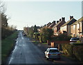
1
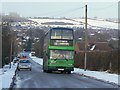
Bus to Loughborough
Climbing out of East Leake on Kirk Ley Road in snowy February 2009. Although the South Notts company was taken over by Nottingham City Transport over a decade earlier, the name has been retained. The dark blue is also continued from the old company livery.
Image: © Alan Murray-Rust
Taken: 3 Feb 2009
0.02 miles
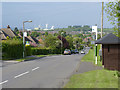
2
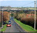
East Leake, Notts
The southern end of Kirk Ley Road. Buses providing the Loughborough-Nottingham service use this road on the Melton Road (the A6006)- East Leake section.
Image: © David Hallam-Jones
Taken: 9 Nov 2014
0.02 miles
3
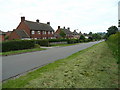
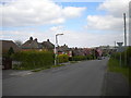
Kirk Ley Road, East Leake
View north towards the village centre.
Image: © Jonathan Billinger
Taken: 13 Jun 2008
0.04 miles
4
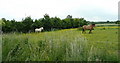
Paddock east of Kirk Ley Road
Inhabited by two horses.
Image: © Jonathan Billinger
Taken: 13 Jun 2008
0.05 miles
5
East Leake, Notts
Kirk Ley Road. The Nottingham-Loughborough bus service (Nottingham City Transport No.1 Service) uses this road between East Leake and Melton Road (the A6006).
Image: © David Hallam-Jones
Taken: 9 Nov 2014
0.07 miles
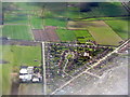
6
Looking down Kirk Ley Road
Looking across the village of East Leake with the gypsum works in the distance.
Image: © Alan Murray-Rust
Taken: 15 May 2014
0.07 miles
7
A corner of East Leake
A triangle of what looks like 1930s housing, with long gardens on the edge of the village, bounded by Rempstone Road, Woodgate Road and Kirk Ley Road, and penetrated by Bley Avenue. The glasshouses and polytunnels are a nursery and microprogation laboratory supplying the garden trade in the UK and Europe http://www.micropropagation-services.co.uk/page2.html
Image: © M J Richardson
Taken: 5 Apr 2016
0.08 miles
8
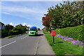
Woodgate Road heading south-west out of East Leake
The Z4 bus service runs between East Leake, Kegworth (East Midlands Airport) and Sutton Bonington, and is a Nottsbus On Demand service.
Image: © Tim Heaton
Taken: 5 May 2024
0.08 miles
10
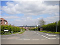
Top of Kirk Ley Road, East Leake
The southernmost point in East Leake village, where Kirk Ley Road meets Rempstone Road.
Image: © Richard Vince
Taken: 18 Apr 2014
0.12 miles