IMAGES TAKEN NEAR TO
Anning Crescent, LE12 6AW
Introduction
This page details the photographs taken nearby to Anning Crescent, LE12 6AW by members of the Geograph project.
The Geograph project started in 2005 with the aim of publishing, organising and preserving representative images for every square kilometre of Great Britain, Ireland and the Isle of Man.

There are currently over 7.5m images from over14,400 individuals and you can help contribute to the project by visiting https://www.geograph.org.uk
Image Map (Loading...)


Getting Data...Please wait
Leaflet Map data © OpenStreetMap
Images are licensed for reuse under creativecommons.org/licenses/by-sa/2.0
Notes
- Clicking on the map will re-center to the selected point.
- The higher the marker number, the further away the image location is from the centre of the postcode.
Image Listing (19 Images Found)
Images are licensed for reuse under creativecommons.org/licenses/by-sa/2.0
Image
Details
Distance
1
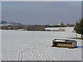
Footpath from Rempstone Road
The footmarks show that the snow has not deterred local walkers. in the distance can be seen the spire of East Leake church, and the gypsum factory to the north of the village.
Image: © Alan Murray-Rust
Taken: 3 Feb 2009
0.06 miles
2
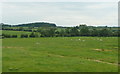
South Nottinghamshire countryside
View south-west of Castle Hill, East Leake, towards the woodland near Whitehills Farm.
Image: © Jonathan Billinger
Taken: 13 Jun 2008
0.11 miles
3
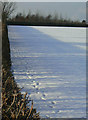
Hedge shadow on snow
The low winter sun casts a long shadow of the hedge on the previous night's snowfall. Although not nearly as heavy as in other parts of the country, it was still the most significant fall for several years.
Image: © Alan Murray-Rust
Taken: 3 Feb 2009
0.12 miles
4
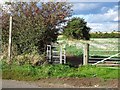
Footpath to East Leake
Through the broken kissing gate, to the left of the hedge.
Image: © Ian Calderwood
Taken: 23 Sep 2018
0.13 miles
5
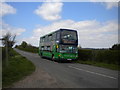
Bus on Rempstone Road south of East Leake
Nottingham City Transport 714, one of that operator's large fleet of Scania/East Lancs (later Optare) OmniDekkas, heads along Rempstone Road on its way from Nottingham to Loughborough on route 1. This was the old South Notts route; NCT bought South Notts in the 1990s and initially retained its name and livery for this route (among others), though now the only remnant on the buses is the navy route branding.
Image: © Richard Vince
Taken: 18 Apr 2014
0.15 miles
6
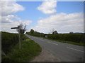
Rempstone Road south of East Leake (1)
Looking from the north end of one public footpath towards the south end of another. On the left, a bench has been provided so that walkers may rest comfortably between paths.
Image: © Richard Vince
Taken: 18 Apr 2014
0.15 miles
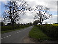
7
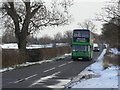
Rempstone Road in the snow
The February 2009 snowfall was considered to be unusually heavy, but compare more or less the same location in 1979 Image
Image: © Alan Murray-Rust
Taken: 3 Feb 2009
0.15 miles
9
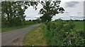
Rempstone Road south of East Leake (2)
Looking towards Rempstone.
Image: © Richard Vince
Taken: 18 Apr 2014
0.15 miles
10
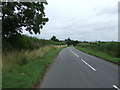
Loughborough Road
Heading north towards East Leake.
Image: © JThomas
Taken: 17 Aug 2013
0.16 miles