IMAGES TAKEN NEAR TO
Mundy Close, LOUGHBOROUGH, LE12 5AQ
Introduction
This page details the photographs taken nearby to Mundy Close, LE12 5AQ by members of the Geograph project.
The Geograph project started in 2005 with the aim of publishing, organising and preserving representative images for every square kilometre of Great Britain, Ireland and the Isle of Man.

There are currently over 7.5m images from over14,400 individuals and you can help contribute to the project by visiting https://www.geograph.org.uk
Image Map (Loading...)


Getting Data...Please wait
Leaflet Map data © OpenStreetMap
Images are licensed for reuse under creativecommons.org/licenses/by-sa/2.0
Notes
- Clicking on the map will re-center to the selected point.
- The higher the marker number, the further away the image location is from the centre of the postcode.
Image Listing (51 Images Found)
Images are licensed for reuse under creativecommons.org/licenses/by-sa/2.0
Image
Details
Distance
1
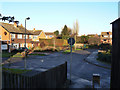
Mundy Close
A small cul-de-sac of (probably) 1970s houses.
Image: © Alan Murray-Rust
Taken: 12 Dec 2011
0.01 miles
2
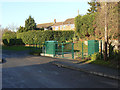
Pump on Seymour Road
Lying as it does at the lowest point of the village, my guess is that this is a sewage pump, although there is no sign, which is unusual.
Image: © Alan Murray-Rust
Taken: 12 Dec 2011
0.04 miles
3
Brook Street
This takes its name from the brook which is now culverted under the road.
Image: © Alan Murray-Rust
Taken: 12 Dec 2011
0.05 miles
4
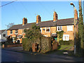
Cottages on Loughborough Road
An attractive set of 4 late 19th century cottages.
Image: © Alan Murray-Rust
Taken: 12 Dec 2011
0.05 miles
5
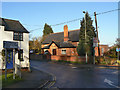
Burton Village Hall
Built in 1909 as a memorial to Percy St Maur, brother of the then occupant of Burton Hall, Lord Ernest St Maur. The death of Percy prompted Lord Ernest and his other brother, the Duke of Somerset, to build the hall at their own expense; the original project had been for the hall to be funded by subscription amongst local residents.
The hall has not served its intended purpose for significant periods of its existence. During the first World War it was used as a convalescent station for wounded Belgian soldiers. In the second World War it became a canteen for HM forces at the nearby airfield, for nearly 2 1/2 years.
After the war due to an influx of Polish refugees, it became a supplementary classroom to the local school, and it was not until the opening of the current school in 1966 that it was able to revert to its intended use for community activities.
(Source of information - Wolds Historical Organisation: http://www.hoap.co.uk/who/burton04.htm )
Image: © Alan Murray-Rust
Taken: 12 Dec 2011
0.05 miles
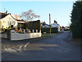
6
Seymour Road, Burton on the Wolds
A modern housing estate built around a road which led to an old farm
Image: © David Smith
Taken: 8 Sep 2023
0.06 miles
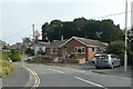
7
Loughborough Road in Burton on the Wolds
Image: © Mat Fascione
Taken: 28 Jun 2008
0.06 miles
9

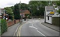
Burton village centre
The cross roads in the centre of the village, now with a mini-roundabout. The main road is the B676 between Loughborough and Melton Mowbray.
Image: © Alan Murray-Rust
Taken: 12 Dec 2011
0.07 miles
10
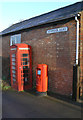
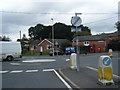
Seymour Road/Burton on The Wolds postbox (ref. LE12 84)
The current style of E II R pillar box, accompanied by a K6 telephone kiosk, still with functioning telephone. The kiosk is Listed Grade II.
Image: © Alan Murray-Rust
Taken: 12 Dec 2011
0.07 miles