IMAGES TAKEN NEAR TO
Barsby Drive, LOUGHBOROUGH, LE11 5UJ
Introduction
This page details the photographs taken nearby to Barsby Drive, LE11 5UJ by members of the Geograph project.
The Geograph project started in 2005 with the aim of publishing, organising and preserving representative images for every square kilometre of Great Britain, Ireland and the Isle of Man.

There are currently over 7.5m images from over14,400 individuals and you can help contribute to the project by visiting https://www.geograph.org.uk
Image Map (Loading...)


Getting Data...Please wait
Leaflet Map data © OpenStreetMap
Images are licensed for reuse under creativecommons.org/licenses/by-sa/2.0
Notes
- Clicking on the map will re-center to the selected point.
- The higher the marker number, the further away the image location is from the centre of the postcode.
Image Listing (7 Images Found)
Images are licensed for reuse under creativecommons.org/licenses/by-sa/2.0
Image
Details
Distance
2
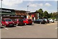
Car park and outdoor play area, McDonald's
Image: © Mark Anderson
Taken: 24 Jul 2019
0.15 miles
4
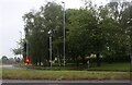
Warwick Way junction with Braddon Road
Image: © Mark Anderson
Taken: 24 Jul 2019
0.20 miles
6
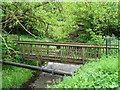
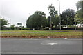
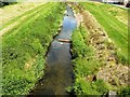
Footbridge over Black Brook
Black Brook runs in two channels here. One is the natural channel of the brook and the other is the former mill race for Dishley Mill. This bridge crosses the natural channel.
Image: © Ian Calderwood
Taken: 24 May 2016
0.23 miles
7
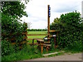
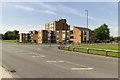
Man and dog stile at Loughborough Rugby Football Club
Image: © Ian Calderwood
Taken: 24 May 2016
0.25 miles