IMAGES TAKEN NEAR TO
Darwin Crescent, LOUGHBOROUGH, LE11 5SA
Introduction
This page details the photographs taken nearby to Darwin Crescent, LE11 5SA by members of the Geograph project.
The Geograph project started in 2005 with the aim of publishing, organising and preserving representative images for every square kilometre of Great Britain, Ireland and the Isle of Man.

There are currently over 7.5m images from over14,400 individuals and you can help contribute to the project by visiting https://www.geograph.org.uk
Image Map
Images are licensed for reuse under creativecommons.org/licenses/by-sa/2.0
Notes
- Clicking on the map will re-center to the selected point.
- The higher the marker number, the further away the image location is from the centre of the postcode.
Image Listing (12 Images Found)
Images are licensed for reuse under creativecommons.org/licenses/by-sa/2.0
Image
Details
Distance
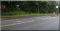
2
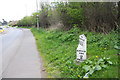
Milestone in verge of Derby Road (A6)
The milestone indicates London 111, Loughborough (Thorpe Acre) 2 and Derby 15
Image: © Roger Templeman
Taken: 8 Apr 2016
0.03 miles
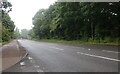
3
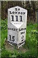
Old Milepost by the A6, Derby Road, Loughborough
Cast iron post by the A6, in parish of HATHERN (CHARNWOOD District), Derby Road, Pear Tree Lane junction, West of Dishley Grange, on verge, on South side of road. Gamble iron casting, erected by the Loughborough to Cavendish Bridge turnpike trust in the 19th century.
Inscription reads:-
: DERBY / 15 / PARISH : : TO / LONDON / 111 : : LOUGH / BRO / 2 / THORPE / ACRE :
Maker:-
: GAMBLE :
Grade II listed. List Entry Number: 1361161
https://historicengland.org.uk/listing/the-list/list-entry/1361161
Milestone Society National ID: LE_LM111.
Image: © J Higgins
Taken: 1 Nov 2004
0.05 miles
4
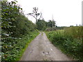
Hathern, Pear Tree Lane
Bridleway and track linking Derby and Hathern Roads.
Image: © Mike Faherty
Taken: 7 Oct 2012
0.07 miles
5
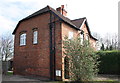
Dishley Cottages, Derby Road
There is an OS benchmark Image on the near corner of the houses, left of the pipe leading up to the white utility cabinet
Image: © Roger Templeman
Taken: 8 Apr 2016
0.08 miles
6
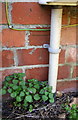
Benchmark on Dishley Cottages
Ordnance Survey cut mark benchmark described on the Bench Mark at http://www.bench-marks.org.uk/bm74737
Image: © Roger Templeman
Taken: 8 Apr 2016
0.08 miles
9
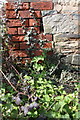
Benchmark on Dishley Grange outbuilding
Ordnance Survey cut mark benchmark described on the Bench Mark Database at http://www.bench-marks.org.uk/bm74738
Image: © Roger Templeman
Taken: 8 Apr 2016
0.16 miles
10
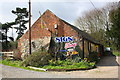
'Sign Shop' premises at Dishley Grange
There is an OS benchmark Image on a stone right of the bricks on the left hand corner of the outbuilding
Image: © Roger Templeman
Taken: 8 Apr 2016
0.16 miles