IMAGES TAKEN NEAR TO
Matthew Arnold Court, LOUGHBOROUGH, LE11 5JS
Introduction
This page details the photographs taken nearby to Matthew Arnold Court, LE11 5JS by members of the Geograph project.
The Geograph project started in 2005 with the aim of publishing, organising and preserving representative images for every square kilometre of Great Britain, Ireland and the Isle of Man.

There are currently over 7.5m images from over14,400 individuals and you can help contribute to the project by visiting https://www.geograph.org.uk
Image Map (22 Images)


Getting Data...Please wait
Leaflet Map data © OpenStreetMap
Images are licensed for reuse under creativecommons.org/licenses/by-sa/2.0
Notes
- Clicking on the map will re-center to the selected point.
- The higher the marker number, the further away the image location is from the centre of the postcode.
Image Listing (22 Images Found)
Images are licensed for reuse under creativecommons.org/licenses/by-sa/2.0
Image
Details
Distance
1
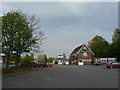
The Maltings, Knight Thorpe
Modern estate pub on Knightthorpe Road. The name does not appear to have any local historic reference.
Image: © Alan Murray-Rust
Taken: 16 Apr 2011
0.09 miles
2
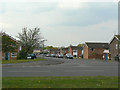
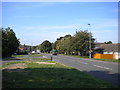
Windsor Road
Estate housing in the western suburbs of Loughborough.
Image: © Alan Murray-Rust
Taken: 16 Apr 2011
0.09 miles
3
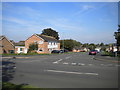
South end of Windsor Road, Thorpe Acre
Seen from Knightthorpe Road.
Image: © Richard Vince
Taken: 1 Sep 2018
0.10 miles
4
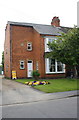
'Myrtle Villa', #126 Knightthorpe Road
There is an OS benchmark Image on the side of the house near its front corner, above a side road which leads to A + C Swift Nurseries. The date stone records 'Myrtle Villa 1914'.
Image: © Roger Templeman
Taken: 20 May 2015
0.11 miles
5
Knightthorpe Road, Thorpe Acre
The section west of Epinal Way.
Image: © Richard Vince
Taken: 1 Sep 2018
0.12 miles
6
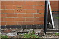
Benchmark on #126 Knightthorpe Road
Ordnance Survey cut mark benchmark described on the Bench Mark Database at http://www.bench-marks.org.uk/bm66873
Image: © Roger Templeman
Taken: 20 May 2015
0.12 miles
7
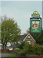
Inn sign for The Maltings
The illustration is not indicative of any particularly building that used to exist in the locality.
Image: © Alan Murray-Rust
Taken: 16 Apr 2011
0.12 miles
8
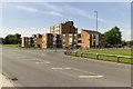
Warwick Way junction with Braddon Road
Image: © Mark Anderson
Taken: 24 Jul 2019
0.18 miles
9
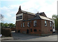
The Plough Inn, Thorpe Acre Road
There is an OS benchmark Image on the near corner, left hand face, of the pub
Image: © Roger Templeman
Taken: 8 Apr 2016
0.18 miles
10
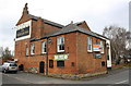
The Plough Inn, Thorpe Acre
This is the old village pub, one of the few old buildings of the village remaining. Changes in the road layout means that it now turns its back on the main road. The lane to the left of the building was once a through lane, but now simply leads to an enclosed parking area.
The range of buildings nearest the camera was probably the brewhouse, to judge by the large chimney stack.
Image: © Alan Murray-Rust
Taken: 16 Apr 2011
0.18 miles