IMAGES TAKEN NEAR TO
Knightthorpe Road, LOUGHBOROUGH, LE11 5JR
Introduction
This page details the photographs taken nearby to Knightthorpe Road, LE11 5JR by members of the Geograph project.
The Geograph project started in 2005 with the aim of publishing, organising and preserving representative images for every square kilometre of Great Britain, Ireland and the Isle of Man.

There are currently over 7.5m images from over14,400 individuals and you can help contribute to the project by visiting https://www.geograph.org.uk
Image Map
Images are licensed for reuse under creativecommons.org/licenses/by-sa/2.0
Notes
- Clicking on the map will re-center to the selected point.
- The higher the marker number, the further away the image location is from the centre of the postcode.
Image Listing (15 Images Found)
Images are licensed for reuse under creativecommons.org/licenses/by-sa/2.0
Image
Details
Distance
1
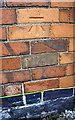
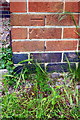
Benchmark on #119 Knightthorpe Road
Ordnance Survey cut mark benchmark described on the Bench Mark Database at http://www.bench-marks.org.uk/bm66872
Image: © Roger Templeman
Taken: 20 May 2015
0.03 miles
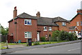
2
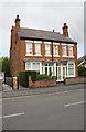
Semi-detached pair on Knightthorpe Road
There is an OS benchmark Image on the side of the left hand house near its front corner
Image: © Roger Templeman
Taken: 20 May 2015
0.03 miles
3
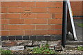
Benchmark on #126 Knightthorpe Road
Ordnance Survey cut mark benchmark described on the Bench Mark Database at http://www.bench-marks.org.uk/bm66873
Image: © Roger Templeman
Taken: 20 May 2015
0.06 miles
4
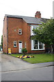
'Myrtle Villa', #126 Knightthorpe Road
There is an OS benchmark Image on the side of the house near its front corner, above a side road which leads to A + C Swift Nurseries. The date stone records 'Myrtle Villa 1914'.
Image: © Roger Templeman
Taken: 20 May 2015
0.07 miles
5

Houses at west end of Alan Moss Road
There is an OS benchmark Image on the front of the nearest house at its left hand corner
Image: © Roger Templeman
Taken: 20 May 2015
0.19 miles
6
Benchmark on #123 Alan Moss Road
Ordnance Survey cut mark benchmark described on the Bench Mark Database at http://www.bench-marks.org.uk/bm66874
Image: © Roger Templeman
Taken: 20 May 2015
0.19 miles
7
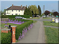
Alyssum hedge
An abundant growth of this pretty violet flower has transformed what would have been a dull privet hedge.
Image: © Alan Murray-Rust
Taken: 16 Apr 2011
0.21 miles
8
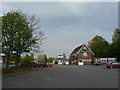
The Maltings, Knight Thorpe
Modern estate pub on Knightthorpe Road. The name does not appear to have any local historic reference.
Image: © Alan Murray-Rust
Taken: 16 Apr 2011
0.21 miles
9
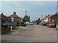
Carington Street
On older maps spelt with two 'r's. This and the two adjacent streets to the west remain unadopted, hence the non-standard road signs. Until Alan Moss Road was constructed they were cul-de-sacs with access from the far end only.
Image: © Alan Murray-Rust
Taken: 16 Apr 2011
0.21 miles
10
Nos. 26 and 28 Knightthorpe Road
The left hand house appears to have some brick-patterned cladding applied to its walls.
Image: © Roger Templeman
Taken: 20 May 2015
0.22 miles