IMAGES TAKEN NEAR TO
Maynard Close, LOUGHBOROUGH, LE11 5ES
Introduction
This page details the photographs taken nearby to Maynard Close, LE11 5ES by members of the Geograph project.
The Geograph project started in 2005 with the aim of publishing, organising and preserving representative images for every square kilometre of Great Britain, Ireland and the Isle of Man.

There are currently over 7.5m images from over14,400 individuals and you can help contribute to the project by visiting https://www.geograph.org.uk
Image Map
Images are licensed for reuse under creativecommons.org/licenses/by-sa/2.0
Notes
- Clicking on the map will re-center to the selected point.
- The higher the marker number, the further away the image location is from the centre of the postcode.
Image Listing (21 Images Found)
Images are licensed for reuse under creativecommons.org/licenses/by-sa/2.0
Image
Details
Distance
1
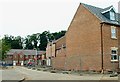
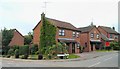
Housebuilding off Maxwell Drive, Loughborough
Image: © Chris J Dixon
Taken: 10 Jun 2005
0.05 miles
2
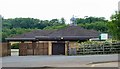
Stonebow Primary School, Loughborough
Image: © Chris J Dixon
Taken: 10 Jun 2005
0.08 miles
7
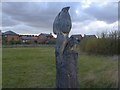
Kingfisher Totem Pole
This sculpture by Martin Heron was erected by the Thorpe Acre Trail as part of a Millennium Trail in the area known as Stonebow Washlands.
Image: © Gerald England
Taken: Unknown
0.14 miles
8
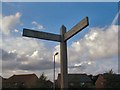
Poetic Sign
This signpost at Stonebow Washlands on the Thorpe Acre Trail was erected in 2000 and has poetry (by Lewis Carroll) on its arms:
"Will you walk a
little faster?"
said a whiting to a snail
Image: © Gerald England
Taken: Unknown
0.15 miles
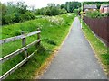
10
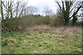
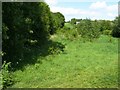
Clearing in scrub area on north side of Pear Tree Lane
Until recently there was a building here with an Ordnance Survey benchmark on a jut on its north face
Image: © Roger Templeman
Taken: 8 Apr 2016
0.16 miles