IMAGES TAKEN NEAR TO
Kinross Crescent, LOUGHBOROUGH, LE11 4UQ
Introduction
This page details the photographs taken nearby to Kinross Crescent, LE11 4UQ by members of the Geograph project.
The Geograph project started in 2005 with the aim of publishing, organising and preserving representative images for every square kilometre of Great Britain, Ireland and the Isle of Man.

There are currently over 7.5m images from over14,400 individuals and you can help contribute to the project by visiting https://www.geograph.org.uk
Image Map (Loading...)


Getting Data...Please wait
Leaflet Map data © OpenStreetMap
Images are licensed for reuse under creativecommons.org/licenses/by-sa/2.0
Notes
- Clicking on the map will re-center to the selected point.
- The higher the marker number, the further away the image location is from the centre of the postcode.
Image Listing (33 Images Found)
Images are licensed for reuse under creativecommons.org/licenses/by-sa/2.0
Image
Details
Distance
1
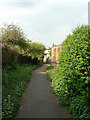
White Bridge Way
A fine name for a very standard housing estate footpath, although it does follow an old footpath alignment. The bridge referred to was probably little more than a normal footbridge over the Black Brook.
Image: © Alan Murray-Rust
Taken: 16 Apr 2011
0.04 miles
2
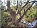
Black Brook from the White Bridge
The Black Brook used to be crossed by an old stone bridge. In 1970 the brook was channelled to the north and a steel bridge was constructed.
Image: © Gerald England
Taken: Unknown
0.06 miles
3
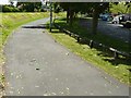
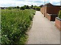
Path by Black Brook Loughborough next to Supermarket
Image: © Andy Jamieson
Taken: 26 May 2009
0.07 miles
4
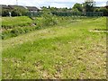
Footbridge over Black Brook Loughborough
Image: © Andy Jamieson
Taken: 26 May 2009
0.07 miles
5
The Plough Inn, Thorpe Acre Road
There is an OS benchmark Image on the near corner, left hand face, of the pub
Image: © Roger Templeman
Taken: 8 Apr 2016
0.08 miles
6
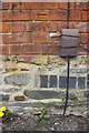
Benchmark on The Plough Inn
Ordnance Survey cut mark benchmark described on the Bench Mark Database at http://www.bench-marks.org.uk/bm74743
Image: © Roger Templeman
Taken: 8 Apr 2016
0.08 miles
7
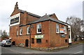
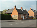
The Plough Inn, Thorpe Acre
This is the old village pub, one of the few old buildings of the village remaining. Changes in the road layout means that it now turns its back on the main road. The lane to the left of the building was once a through lane, but now simply leads to an enclosed parking area.
The range of buildings nearest the camera was probably the brewhouse, to judge by the large chimney stack.
Image: © Alan Murray-Rust
Taken: 16 Apr 2011
0.08 miles
8
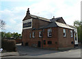
The Plough Inn, Thorpe Acre
The front of the pub faces onto a quiet beer garden.
Image: © Alan Murray-Rust
Taken: 16 Apr 2011
0.08 miles
10
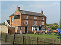
Cottage at Thorpe Acre
Clearly originally a pair of farm cottages, now merged into one as an 'attractive period dwelling'.
Image: © Alan Murray-Rust
Taken: 16 Apr 2011
0.09 miles