IMAGES TAKEN NEAR TO
Petworth Drive, LOUGHBOROUGH, LE11 4TY
Introduction
This page details the photographs taken nearby to Petworth Drive, LE11 4TY by members of the Geograph project.
The Geograph project started in 2005 with the aim of publishing, organising and preserving representative images for every square kilometre of Great Britain, Ireland and the Isle of Man.

There are currently over 7.5m images from over14,400 individuals and you can help contribute to the project by visiting https://www.geograph.org.uk
Image Map
Images are licensed for reuse under creativecommons.org/licenses/by-sa/2.0
Notes
- Clicking on the map will re-center to the selected point.
- The higher the marker number, the further away the image location is from the centre of the postcode.
Image Listing (27 Images Found)
Images are licensed for reuse under creativecommons.org/licenses/by-sa/2.0
Image
Details
Distance
1
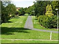
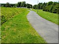
Path leading off Black Brook Loughborough
Image: © Andy Jamieson
Taken: 26 May 2009
0.09 miles
2
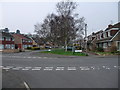
Road junction in Thorpe Acre, Loughborough
Cycle Route 6 goes straight ahead down Coe Avenue
Image: © Tim Heaton
Taken: 22 Mar 2012
0.10 miles
3
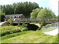
Road bridge over Black Brook Loughborough
Image: © Andy Jamieson
Taken: 26 May 2009
0.10 miles
4
Road bridge over Black Brook Loughborough
Image: © Andy Jamieson
Taken: 26 May 2009
0.10 miles
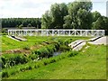
5
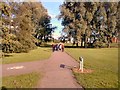
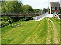
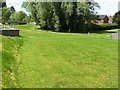
Jubilee Park
The footpath is part of the Thorpe Acre Trail.
Image: © Gerald England
Taken: Unknown
0.11 miles
9
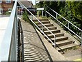
Footbridge over Black Brook Loughborough
Image: © Andy Jamieson
Taken: 26 May 2009
0.12 miles
10
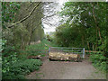
Woodland access
Despite gate and fence, there is clearly significant foot traffic through here.
Image: © Alan Murray-Rust
Taken: 16 Apr 2011
0.12 miles