IMAGES TAKEN NEAR TO
Burns Road, LOUGHBOROUGH, LE11 4NE
Introduction
This page details the photographs taken nearby to Burns Road, LE11 4NE by members of the Geograph project.
The Geograph project started in 2005 with the aim of publishing, organising and preserving representative images for every square kilometre of Great Britain, Ireland and the Isle of Man.

There are currently over 7.5m images from over14,400 individuals and you can help contribute to the project by visiting https://www.geograph.org.uk
Image Map
Images are licensed for reuse under creativecommons.org/licenses/by-sa/2.0
Notes
- Clicking on the map will re-center to the selected point.
- The higher the marker number, the further away the image location is from the centre of the postcode.
Image Listing (40 Images Found)
Images are licensed for reuse under creativecommons.org/licenses/by-sa/2.0
Image
Details
Distance
1
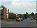
Burns Road
A mix of maisonettes and semidetached houses.
Image: © Alan Murray-Rust
Taken: 16 Apr 2011
0.02 miles
2
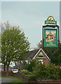
Inn sign for The Maltings
The illustration is not indicative of any particularly building that used to exist in the locality.
Image: © Alan Murray-Rust
Taken: 16 Apr 2011
0.09 miles
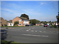
3
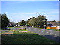
Knightthorpe Road, Thorpe Acre
The section west of Epinal Way.
Image: © Richard Vince
Taken: 1 Sep 2018
0.10 miles
4
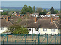
Poets estate
The nearer roofs belong to a post-WW2 housing estate with roads named after British poets.
Image: © Alan Murray-Rust
Taken: 16 Apr 2011
0.11 miles
5
The Maltings, Knight Thorpe
Modern estate pub on Knightthorpe Road. The name does not appear to have any local historic reference.
Image: © Alan Murray-Rust
Taken: 16 Apr 2011
0.11 miles
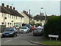
6
South end of Windsor Road, Thorpe Acre
Seen from Knightthorpe Road.
Image: © Richard Vince
Taken: 1 Sep 2018
0.12 miles
7
Wordsworth Road
1950s/60s local authority housing estate with roads named after British poets.
Image: © Alan Murray-Rust
Taken: 16 Apr 2011
0.12 miles
8
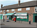
Thorpe Acre Village shopping centre
One convenience store, a hairdresser and the inevitable take-aways. The store was once a post office, but is so no longer. The pillar box (Browning Road | Loughborough ref. LE11 137) still retains vestiges of the Post Office sign on top.
Image: © Alan Murray-Rust
Taken: 16 Apr 2011
0.13 miles
9
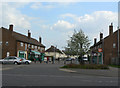
Thorpe Acre Village shopping centre
Not in fact part of the original village, which has virtually disappeared, just a typical 1970s housing estate shopping parade.
Image: © Alan Murray-Rust
Taken: 16 Apr 2011
0.13 miles
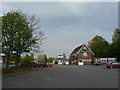
10
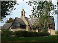
All Saints, Thorpe Acre with Dishley
A small Victorian aisleless church has proved inadequate to serve the needs of post-WWII housing development and has been substantially enlarged in recent years. The original building was designed in 1845 by William Railton in the 'Decorated' style. Listed Grade II.
Image: © Alan Murray-Rust
Taken: 16 Apr 2011
0.15 miles