IMAGES TAKEN NEAR TO
Longcliffe Gardens, LOUGHBOROUGH, LE11 3YQ
Introduction
This page details the photographs taken nearby to Longcliffe Gardens, LE11 3YQ by members of the Geograph project.
The Geograph project started in 2005 with the aim of publishing, organising and preserving representative images for every square kilometre of Great Britain, Ireland and the Isle of Man.

There are currently over 7.5m images from over14,400 individuals and you can help contribute to the project by visiting https://www.geograph.org.uk
Image Map
Images are licensed for reuse under creativecommons.org/licenses/by-sa/2.0
Notes
- Clicking on the map will re-center to the selected point.
- The higher the marker number, the further away the image location is from the centre of the postcode.
Image Listing (19 Images Found)
Images are licensed for reuse under creativecommons.org/licenses/by-sa/2.0
Image
Details
Distance
1
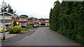
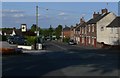
Longcliffe Gardens
Housing stock typical of this area.
Image: © Peter Mackenzie
Taken: 25 Jun 2017
0.02 miles

3
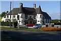
The Priory in Nanpantan
Public house on the corner of Nanpantan Road and Snells Nook Lane.
Image: © Mat Fascione
Taken: 16 May 2010
0.06 miles

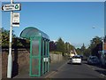
6
Longcliffe Nursing Home
On the cross road in Nanpantan.
Image: © Steve Fareham
Taken: 28 Jun 2008
0.07 miles
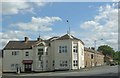
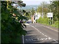
7
Nanpantan Road in Nanpantan, Loughborough
Image: © Mat Fascione
Taken: 16 May 2010
0.08 miles
9
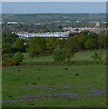
View across Loughborough
Looking northeast from Nanpantan Road.
Image: © Mat Fascione
Taken: 16 May 2010
0.15 miles
10
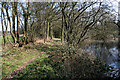
Public footpath off Snell's Nook Lane
This narrow pond alongside the footpath is much overgrown and in the summer is hardly visible from the path or the Golf Club road to the right of the photograph. The pond is probably the only section of the long lost Charnwood Forest Canal, which linked Thringstone to Nanpantan, to still hold water. It was originally built to carry coal and leaves only a few traces along its original route.
There are open fields to the left and the curiously named Snell's Nook Lane is straight ahead.
Image: © Kate Jewell
Taken: 26 Mar 2007
0.17 miles