IMAGES TAKEN NEAR TO
Leconfield Road, LOUGHBOROUGH, LE11 3SQ
Introduction
This page details the photographs taken nearby to Leconfield Road, LE11 3SQ by members of the Geograph project.
The Geograph project started in 2005 with the aim of publishing, organising and preserving representative images for every square kilometre of Great Britain, Ireland and the Isle of Man.

There are currently over 7.5m images from over14,400 individuals and you can help contribute to the project by visiting https://www.geograph.org.uk
Image Map
Images are licensed for reuse under creativecommons.org/licenses/by-sa/2.0
Notes
- Clicking on the map will re-center to the selected point.
- The higher the marker number, the further away the image location is from the centre of the postcode.
Image Listing (20 Images Found)
Images are licensed for reuse under creativecommons.org/licenses/by-sa/2.0
Image
Details
Distance
1
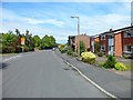
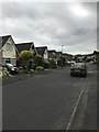
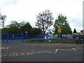
Berkeley Road, Loughborough
Residential area in the Leicestershire town.
Image: © Stephen Sweeney
Taken: 18 Jun 2011
0.12 miles

4
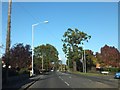
Nanpantan Road at its junction with Watermead Lane
Trees showing autumn colour
Image: © David Smith
Taken: 16 Oct 2012
0.15 miles

8
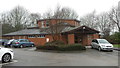
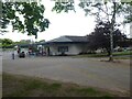
Holywell Evangelical Church
Holywell Evangelical Church is located in Berkeley Road on the west side of Loughborough.
Image: © Peter Mackenzie
Taken: 16 Jan 2017
0.18 miles
9
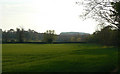
Fields near Nanpantan
Looking from near the Brush Sports Field towards Buck Hill.
Image: © Alan Murray-Rust
Taken: 16 Apr 2011
0.18 miles