IMAGES TAKEN NEAR TO
Patterdale Drive, LOUGHBOROUGH, LE11 3RT
Introduction
This page details the photographs taken nearby to Patterdale Drive, LE11 3RT by members of the Geograph project.
The Geograph project started in 2005 with the aim of publishing, organising and preserving representative images for every square kilometre of Great Britain, Ireland and the Isle of Man.

There are currently over 7.5m images from over14,400 individuals and you can help contribute to the project by visiting https://www.geograph.org.uk
Image Map (Loading...)


Getting Data...Please wait
Leaflet Map data © OpenStreetMap
Images are licensed for reuse under creativecommons.org/licenses/by-sa/2.0
Notes
- Clicking on the map will re-center to the selected point.
- The higher the marker number, the further away the image location is from the centre of the postcode.
Image Listing (16 Images Found)
Images are licensed for reuse under creativecommons.org/licenses/by-sa/2.0
Image
Details
Distance
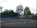
1
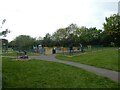
Playground, Kirkstone Drive, Loughborough
Image: © David Smith
Taken: 1 May 2022
0.07 miles
6
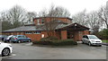
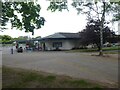
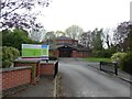
Holywell Evangelical Church
Holywell Evangelical Church is located in Berkeley Road on the west side of Loughborough.
Image: © Peter Mackenzie
Taken: 16 Jan 2017
0.12 miles
9
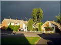
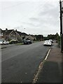
Holywell Drive, Loughborough, before a hailstorm
The road on the left is Coniston Crescent; nos. 87 and 89 Holywell Drive are behind me.
Image: © Alex Cameron
Taken: 7 Jul 2005
0.16 miles