IMAGES TAKEN NEAR TO
Outwoods Road, LOUGHBOROUGH, LE11 3LX
Introduction
This page details the photographs taken nearby to Outwoods Road, LE11 3LX by members of the Geograph project.
The Geograph project started in 2005 with the aim of publishing, organising and preserving representative images for every square kilometre of Great Britain, Ireland and the Isle of Man.

There are currently over 7.5m images from over14,400 individuals and you can help contribute to the project by visiting https://www.geograph.org.uk
Image Map (Loading...)


Getting Data...Please wait
Leaflet Map data © OpenStreetMap
Images are licensed for reuse under creativecommons.org/licenses/by-sa/2.0
Notes
- Clicking on the map will re-center to the selected point.
- The higher the marker number, the further away the image location is from the centre of the postcode.
Image Listing (10 Images Found)
Images are licensed for reuse under creativecommons.org/licenses/by-sa/2.0
Image
Details
Distance
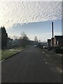
3
Valley Road
Valley Road on the western edge of Loughborough.
Image: © Peter Mackenzie
Taken: 3 Jul 2017
0.18 miles


6
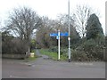
Foot and cycle path beside the stream, Valley Road, Loughborough
Part of the network of cycle paths in Loughborough
Image: © David Smith
Taken: 26 Dec 2018
0.21 miles

8
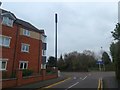
Black communications mast, Woodbrook Road, Loughborough
The majority of masts of this design are painted a light colour; why is this different?
Image: © David Smith
Taken: 26 Dec 2018
0.22 miles
9
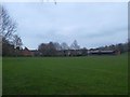
Sports field and changing rooms, by Woodbrook Way
Image: © David Smith
Taken: 26 Dec 2018
0.22 miles
