IMAGES TAKEN NEAR TO
Beck Crescent, LOUGHBOROUGH, LE11 2UT
Introduction
This page details the photographs taken nearby to Beck Crescent, LE11 2UT by members of the Geograph project.
The Geograph project started in 2005 with the aim of publishing, organising and preserving representative images for every square kilometre of Great Britain, Ireland and the Isle of Man.

There are currently over 7.5m images from over14,400 individuals and you can help contribute to the project by visiting https://www.geograph.org.uk
Image Map (Loading...)


Getting Data...Please wait
Leaflet Map data © OpenStreetMap
Images are licensed for reuse under creativecommons.org/licenses/by-sa/2.0
Notes
- Clicking on the map will re-center to the selected point.
- The higher the marker number, the further away the image location is from the centre of the postcode.
Image Listing (8 Images Found)
Images are licensed for reuse under creativecommons.org/licenses/by-sa/2.0
Image
Details
Distance
3
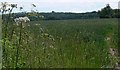
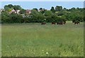
Open space off Beck Crescent, Loughborough
With a small pond on the left and a footbridge across a stream ahead.
Image: © Richard Vince
Taken: 19 Jun 2021
0.07 miles
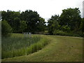
5
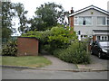
Public footpath off Grasmere Road, Loughborough
Leading to Beck Crescent.
Image: © Richard Vince
Taken: 19 Jun 2021
0.16 miles
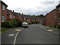
6
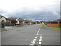
Grasmere Road, Loughborough
Seen from the junction with Atherstone Road (right).
Image: © Richard Vince
Taken: 19 Jun 2021
0.20 miles
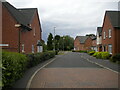
7
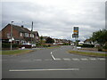
Atherstone Road, Loughborough
Seen from its junction with Fairmeadows Way (right), which continues from here as the western end of Atherstone Road (left).
Image: © Richard Vince
Taken: 19 Jun 2021
0.23 miles