IMAGES TAKEN NEAR TO
Michie Road, LOUGHBOROUGH, LE11 2UQ
Introduction
This page details the photographs taken nearby to Michie Road, LE11 2UQ by members of the Geograph project.
The Geograph project started in 2005 with the aim of publishing, organising and preserving representative images for every square kilometre of Great Britain, Ireland and the Isle of Man.

There are currently over 7.5m images from over14,400 individuals and you can help contribute to the project by visiting https://www.geograph.org.uk
Image Map (Loading...)


Getting Data...Please wait
Leaflet Map data © OpenStreetMap
Images are licensed for reuse under creativecommons.org/licenses/by-sa/2.0
Notes
- Clicking on the map will re-center to the selected point.
- The higher the marker number, the further away the image location is from the centre of the postcode.
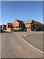
Image Listing (5 Images Found)
Images are licensed for reuse under creativecommons.org/licenses/by-sa/2.0
Image
Details
Distance
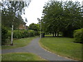
1
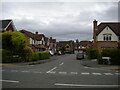
Copse Grove, Hazel Road estate
Off Haddon Way.
Image: © Richard Vince
Taken: 19 Jun 2021
0.16 miles
3
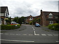
Freesia Close, Hazel Road estate
A cul de sac off Haddon Way.
Image: © Richard Vince
Taken: 19 Jun 2021
0.19 miles
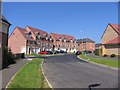
5
Footpath off Haddon Way, Hazel Road estate
Winding between the backs of houses on Freesia Close and Silverbirch Way.
Image: © Richard Vince
Taken: 19 Jun 2021
0.22 miles