IMAGES TAKEN NEAR TO
Hugh Foss Drive, LOUGHBOROUGH, LE11 2NP
Introduction
This page details the photographs taken nearby to Hugh Foss Drive, LE11 2NP by members of the Geograph project.
The Geograph project started in 2005 with the aim of publishing, organising and preserving representative images for every square kilometre of Great Britain, Ireland and the Isle of Man.

There are currently over 7.5m images from over14,400 individuals and you can help contribute to the project by visiting https://www.geograph.org.uk
Image Map (Loading...)


Getting Data...Please wait
Leaflet Map data © OpenStreetMap
Images are licensed for reuse under creativecommons.org/licenses/by-sa/2.0
Notes
- Clicking on the map will re-center to the selected point.
- The higher the marker number, the further away the image location is from the centre of the postcode.
Image Listing (5 Images Found)
Images are licensed for reuse under creativecommons.org/licenses/by-sa/2.0
Image
Details
Distance
1
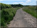
Track to Mucklin Wood
On the southern edge of Loughborough.
Image: © Mat Fascione
Taken: 20 Jun 2010
0.09 miles
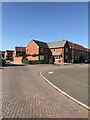
4
Footpath through the houses
A new housing estate on the southern edge of Loughborough.
Image: © Mat Fascione
Taken: 20 Jun 2010
0.12 miles
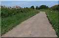
5
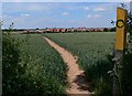
Public footpath across the fields
Heading north along the footpath that runs from Forest Road near Woodhouse, to a new housing estate on the southern edge of Loughborough.
Image: © Mat Fascione
Taken: 20 Jun 2010
0.13 miles