IMAGES TAKEN NEAR TO
Pulteney Avenue, LOUGHBOROUGH, LE11 2NA
Introduction
This page details the photographs taken nearby to Pulteney Avenue, LE11 2NA by members of the Geograph project.
The Geograph project started in 2005 with the aim of publishing, organising and preserving representative images for every square kilometre of Great Britain, Ireland and the Isle of Man.

There are currently over 7.5m images from over14,400 individuals and you can help contribute to the project by visiting https://www.geograph.org.uk
Image Map (Loading...)


Getting Data...Please wait
Leaflet Map data © OpenStreetMap
Images are licensed for reuse under creativecommons.org/licenses/by-sa/2.0
Notes
- Clicking on the map will re-center to the selected point.
- The higher the marker number, the further away the image location is from the centre of the postcode.
Image Listing (18 Images Found)
Images are licensed for reuse under creativecommons.org/licenses/by-sa/2.0
Image
Details
Distance
1
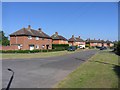
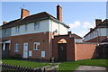
Manor Road Shelthorpe
Part of a very large housing estate built in the mid 20th century by the local council.
Image: © Andrew Tatlow
Taken: 17 Jun 2006
0.07 miles
2
#65 Ling Road
There is an OS benchmark Image on the near corner, right hand face, of the bungalow
Image: © Roger Templeman
Taken: 30 Sep 2015
0.09 miles
3
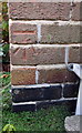
Benchmark on #65 Ling Road
Ordnance Survey cut mark benchmark described on the Bench Mark Database at http://www.bench-marks.org.uk/bm70597
Image: © Roger Templeman
Taken: 30 Sep 2015
0.09 miles
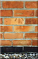
7
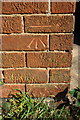
Benchmark on #28 Ling Road
Ordnance Survey cut mark benchmark on #28 Ling Road described on the Bench Mark Database at http://www.bench-marks.org.uk/bm70596
Image: © Roger Templeman
Taken: 30 Sep 2015
0.14 miles
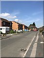
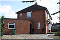
8
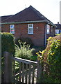
#28 Ling Road
There is an OS benchmark Image on the left hand side of the archway
Image: © Roger Templeman
Taken: 30 Sep 2015
0.14 miles
9
Benchmark on outbuilding of #104 Manor Road
Ordnance Survey cut mark benchmark described on the Bench Mark Database at http://www.bench-marks.org.uk/bm70599
Image: © Roger Templeman
Taken: 30 Sep 2015
0.19 miles
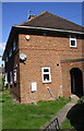
10
Outbuilding and house at #104 Manor Road
There is an OS benchmark Image on the outbuilding wall left of the junction with the archway wall
Image: © Roger Templeman
Taken: 30 Sep 2015
0.19 miles