IMAGES TAKEN NEAR TO
Allendale Road, LOUGHBOROUGH, LE11 2HX
Introduction
This page details the photographs taken nearby to Allendale Road, LE11 2HX by members of the Geograph project.
The Geograph project started in 2005 with the aim of publishing, organising and preserving representative images for every square kilometre of Great Britain, Ireland and the Isle of Man.

There are currently over 7.5m images from over14,400 individuals and you can help contribute to the project by visiting https://www.geograph.org.uk
Image Map
Images are licensed for reuse under creativecommons.org/licenses/by-sa/2.0
Notes
- Clicking on the map will re-center to the selected point.
- The higher the marker number, the further away the image location is from the centre of the postcode.
Image Listing (9 Images Found)
Images are licensed for reuse under creativecommons.org/licenses/by-sa/2.0
Image
Details
Distance
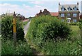
1
End of the world
This is the end of Shelthorpe, a large council housing estate. There's another world out there somewhere Image
Image: © Andrew Tatlow
Taken: 17 Jun 2006
0.13 miles
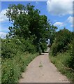
2
Footpath through the houses
A new housing estate on the southern edge of Loughborough.
Image: © Mat Fascione
Taken: 20 Jun 2010
0.14 miles
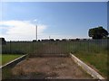
4
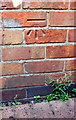
Benchmark on outbuilding at #91 Manor Road
Ordnance Survey cut mark benchmark described on the Bench Mark Database at http://www.bench-marks.org.uk/bm70598
Image: © Roger Templeman
Taken: 30 Sep 2015
0.21 miles
5
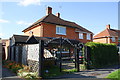
#91 Manor Road with outbuilding
There is an OS benchmark Image on the brick outbuilding (at the left hand side of the image)
Image: © Roger Templeman
Taken: 30 Sep 2015
0.21 miles
6
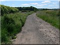
Track to Mucklin Wood
On the southern edge of Loughborough.
Image: © Mat Fascione
Taken: 20 Jun 2010
0.22 miles
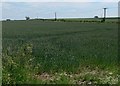
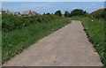
7
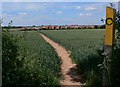
Public footpath across the fields
Heading north along the footpath that runs from Forest Road near Woodhouse, to a new housing estate on the southern edge of Loughborough.
Image: © Mat Fascione
Taken: 20 Jun 2010
0.23 miles