IMAGES TAKEN NEAR TO
Canal Bank, LOUGHBOROUGH, LE11 1QE
Introduction
This page details the photographs taken nearby to Canal Bank, LE11 1QE by members of the Geograph project.
The Geograph project started in 2005 with the aim of publishing, organising and preserving representative images for every square kilometre of Great Britain, Ireland and the Isle of Man.

There are currently over 7.5m images from over14,400 individuals and you can help contribute to the project by visiting https://www.geograph.org.uk
Image Map
Images are licensed for reuse under creativecommons.org/licenses/by-sa/2.0
Notes
- Clicking on the map will re-center to the selected point.
- The higher the marker number, the further away the image location is from the centre of the postcode.
Image Listing (31 Images Found)
Images are licensed for reuse under creativecommons.org/licenses/by-sa/2.0
Image
Details
Distance
1
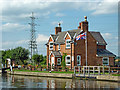
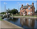
Lock keeper's house north of Loughborough, Leicestershire
This house is by Bishop's Meadow Lock, No 54 on the Grand Union Canal(Leicester Section)/Soar Navigation.
The Loughborough Navigation (including the River Soar) was bought by the Grand Union Canal Carrying Company in 1932.
Image: © Roger Kidd
Taken: 26 Aug 2013
0.00 miles
2
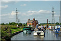
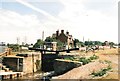
Congestion at Bishop's Meadow Lock, Loughborough
August Bank Holiday approaches Bishop's Meadow Lock, No 54 on the Grand Union Canal(Leicester Section)/Soar Navigation. The lock provides a rise (or fall) of 8ft 7in (2·6 metres) between the canal and the river levels. The canal rejoins the River Soar about eight hundred metres ahead.
The locks are wide and full length (72 feet) so the two boats in front, and we probably fit in together (I can't remember if we did).
The Loughborough Navigation (including the River Soar) was bought by the Grand Union Canal Carrying Company in 1932.
Image: © Roger Kidd
Taken: 26 Aug 2013
0.00 miles
3
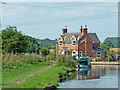
House by Bishop's Meadow Lock near Loughborough
This is a telephoto assisted image looking along the towpath towards Bishop's Meadow Lock, No 54 on the Grand Union Canal(Leicester Section)/Soar Navigation.
The Loughborough Navigation (including the River Soar) was bought by the Grand Union Canal Carrying Company in 1932.
Image: © Roger Kidd
Taken: 26 Aug 2013
0.00 miles
4

Bishop Meadow Lock and keeper's cottage
On the Grand Union Canal Loughborough Navigation
Image: © Andrew Abbott
Taken: 26 Jul 2020
0.01 miles
5
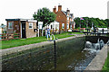
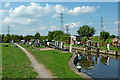
Bishop's Meadow Lock north of Loughborough, Leicestershire
Bishop's Meadow Lock is No 54 on the Grand Union Canal(Leicester Section)/Soar Navigation. It is wide enough for two narrowboats, and full length (72 feet). The lock provides a rise (or fall) of 8ft 7in (2·6 metres) between the canal and the river level below. The canal channel diverged from the River Soar about eight hundred metres behind the camera, and rejoins it by Pilling's Lock about four miles to the south-east.
The old Loughborough Navigation (including the River Soar) was bought by the Grand Union Canal Carrying Company in 1932.
Image: © Roger Kidd
Taken: 26 Aug 2013
0.01 miles
6
Bishops Meadow Lock House
On the Grand Union Canal north of Loughborough in Leicestershire.
Image: © Mat Fascione
Taken: 4 Sep 2007
0.01 miles
8
Bishop's Meadow Lock north of Loughborough, Leicestershire
Bishop's Meadow Lock is No 54 on the Grand Union Canal(Leicester Section)/Soar Navigation. It is wide enough for two narrowboats, and full length (72 feet). The lock provides a rise (or fall) of 8ft 7in (2·6 metres) between the canal and the river level below. The canal rejoins the River Soar about eight hundred metres ahead.
The old Loughborough Navigation (including the River Soar) was bought by the Grand Union Canal Carrying Company in 1932.
Image: © Roger Kidd
Taken: 26 Aug 2013
0.02 miles
9
![Flying the Yorkshire flag at Bishop Meadow lock [no 54]](https://s1.geograph.org.uk/geophotos/06/18/18/6181861_a5805fae_120x120.jpg)
Flying the Yorkshire flag at Bishop Meadow lock [no 54]
Just north of Loughborough, in Leicestershire.
Image: © Christine Johnstone
Taken: 10 May 2019
0.02 miles
10
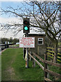
Flood Warning Light
Grand Union Canal - Loughborough Navigation. River Soar and canal meet just below the lock. Traffic light used to give warning of unsafe navigation conditions on the river beyond the protection of the lock.
Image: © Mike Todd
Taken: 23 Mar 2011
0.02 miles