IMAGES TAKEN NEAR TO
Deer Acre, LOUGHBOROUGH, LE11 1LZ
Introduction
This page details the photographs taken nearby to Deer Acre, LE11 1LZ by members of the Geograph project.
The Geograph project started in 2005 with the aim of publishing, organising and preserving representative images for every square kilometre of Great Britain, Ireland and the Isle of Man.

There are currently over 7.5m images from over14,400 individuals and you can help contribute to the project by visiting https://www.geograph.org.uk
Image Map
Images are licensed for reuse under creativecommons.org/licenses/by-sa/2.0
Notes
- Clicking on the map will re-center to the selected point.
- The higher the marker number, the further away the image location is from the centre of the postcode.
Image Listing (37 Images Found)
Images are licensed for reuse under creativecommons.org/licenses/by-sa/2.0
Image
Details
Distance
1
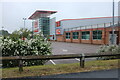
B&Q on Belton Road, Loughborough
B&Q stands for Block and Quayle founded in Eastleigh, Hampshire.
Image: © David Howard
Taken: 5 Jun 2022
0.12 miles
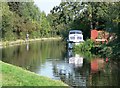
2

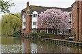
Grand Union Canal
Looking north from Chain Bridge at Canal Bank.
Image: © Thomas Nugent
Taken: 8 Sep 2014
0.14 miles
3
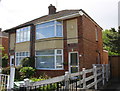
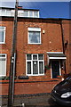
Semi-detached houses on Bottleacre Lane
There is an OS benchmark Image on the side of the right hand house near its front corner
Image: © Roger Templeman
Taken: 20 May 2015
0.15 miles
4
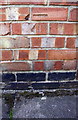
Benchmark on #142 Bottleacre Lane
Ordnance Survey cut mark benchmark described on the Bench Mark Database at http://www.bench-marks.org.uk/bm66871
Image: © Roger Templeman
Taken: 20 May 2015
0.15 miles
5

Millennium Falcon
On the Grand Union Canal in Loughborough.
Image: © Andrew Abbott
Taken: 26 Jul 2020
0.16 miles
6
Canalside apartments in Rendell Street
Image: © David Martin
Taken: 25 Mar 2024
0.16 miles
7
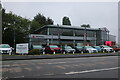
Pentagon Vauxhall on Belton Road, Loughborough
The whole side of this road is a series of car dealerships.
Image: © David Howard
Taken: 5 Jun 2022
0.17 miles
9
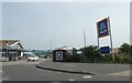
Entrance to Aldi supermarket, Belton Road, Loughborough
Image: © David Smith
Taken: 8 Sep 2023
0.19 miles
10
#87 Lower Cambridge Street
Ordnance Survey documents indicate that a benchmark levelled at 40.465m above Newlyn Datum was verified in 1965 on the front of the house right of its front door
Image: © Roger Templeman
Taken: 30 Apr 2016
0.19 miles