IMAGES TAKEN NEAR TO
Charnwood Trade Park, Clarence Street, LOUGHBOROUGH, LE11 1FW
Introduction
This page details the photographs taken nearby to Charnwood Trade Park, Clarence Street, LE11 1FW by members of the Geograph project.
The Geograph project started in 2005 with the aim of publishing, organising and preserving representative images for every square kilometre of Great Britain, Ireland and the Isle of Man.

There are currently over 7.5m images from over14,400 individuals and you can help contribute to the project by visiting https://www.geograph.org.uk
Image Map
Images are licensed for reuse under creativecommons.org/licenses/by-sa/2.0
Notes
- Clicking on the map will re-center to the selected point.
- The higher the marker number, the further away the image location is from the centre of the postcode.
Image Listing (248 Images Found)
Images are licensed for reuse under creativecommons.org/licenses/by-sa/2.0
Image
Details
Distance
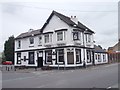
1
Jack O' Lantern pub, Loughborough
Another closed pub.
Image: © Robert Eva
Taken: 7 Oct 2017
0.04 miles
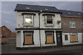
2
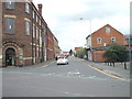
#65 Clarence Road
There were toilets of a pub to the right of the building: now demolished with the loss of an Ordnance Survey cut mark benchmark, http://www.bench-marks.org.uk/bm24034
Image: © Roger Templeman
Taken: 30 Apr 2016
0.05 miles
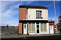
4
Benchmark on factory, Clarence Street
Ordnance Survey cut mark benchmark described on the Bench Mark Database at http://www.bench-marks.org.uk/bm24033
Image: © Roger Templeman
Taken: 30 Apr 2016
0.05 miles
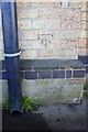
5
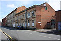
Factories on Clarence Street
There is an OS benchmark Image on the front of the factory right of the downpipe behind the parked car
Image: © Roger Templeman
Taken: 30 Apr 2016
0.05 miles
7
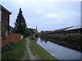
Grand Union Canal, Loughborough (1)
Looking east towards the Nottingham Road bridge.
Image: © Richard Vince
Taken: 13 Sep 2014
0.06 miles
8
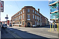
Former Towles hosiery factory, Nottingham Road/Clarence Road
A late 19th century locally listed building, currently occupied by SOFA, a charity recycling furniture and electrical goods for retail sale.
Image: © Robin Webster
Taken: 25 Mar 2016
0.06 miles
9
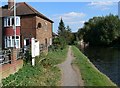
Grand Union Canal & towpath
The house is at the end of Glebe Street in Loughborough, Leicestershire.
Image: © Mat Fascione
Taken: 4 Sep 2007
0.06 miles
10
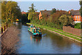
Loughborough Canal
Grand Union Canal in the centre of Loughborough.
Image: © Wayland Smith
Taken: 10 Oct 2010
0.07 miles