IMAGES TAKEN NEAR TO
Morley Street, LOUGHBOROUGH, LE11 1EW
Introduction
This page details the photographs taken nearby to Morley Street, LE11 1EW by members of the Geograph project.
The Geograph project started in 2005 with the aim of publishing, organising and preserving representative images for every square kilometre of Great Britain, Ireland and the Isle of Man.

There are currently over 7.5m images from over14,400 individuals and you can help contribute to the project by visiting https://www.geograph.org.uk
Image Map
Images are licensed for reuse under creativecommons.org/licenses/by-sa/2.0
Notes
- Clicking on the map will re-center to the selected point.
- The higher the marker number, the further away the image location is from the centre of the postcode.
Image Listing (149 Images Found)
Images are licensed for reuse under creativecommons.org/licenses/by-sa/2.0
Image
Details
Distance
3
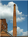
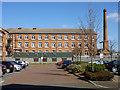
Former mill chimney in Loughborough, Leicestershire
Seen from the Grand Union Canal in 2013, this disused chimney is part of the Victorian mill occupied from the early 1950s to 2018 by the 3M Healthcare company.
The mill is to be redeveloped into flats, shops and offices, but the chimney will be preserved.
Image]
Image]
Image: © Roger Kidd
Taken: 26 Aug 2013
0.07 miles
4
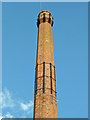
Former mill chimney in Loughborough, Leicestershire
Seen from the Grand Union Canal in 2013, this disused chimney is part of the Victorian mill occupied from the early 1950s to 2018 by the 3M Healthcare company.
The mill is to be redeveloped into flats, shops and offices, but the chimney will be preserved.
Image]
Image]
Image: © Roger Kidd
Taken: 26 Aug 2013
0.07 miles
5
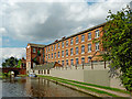
Former mill in Loughborough in Leicestershire
In this 2013 image taken from the Grand Union Canal the former Victorian mill is still the HQ of 3M Healthcare. In 2018 3M moved out, and the mill is to be transformed into offices, apartments and shops. https://www.leicestermercury.co.uk/news/local-news/old-3m-health-care-hq-1507438
Ahead is Nottingham Road Bridge, No 38.
Image]
Image]
Image]
Image: © Roger Kidd
Taken: 26 Aug 2013
0.08 miles
7
Station Boulevard - Nottingham Road
Image: © Betty Longbottom
Taken: 9 May 2012
0.08 miles
8
Nottingham Road railway bridge near Loughborough Station
Ordnance Survey records indicate that a benchmark levelled at 44.586m above Newlyn Datum was verified in 1966 on the bridge parapet on the SE side of the road above the centre of the railway
Image: © Roger Templeman
Taken: 20 May 2015
0.08 miles
9
3M Healthcare, Loughborough
One of two sites for the company in the town, this one is offices. Formerly it was mapped as a hosiery manufactory. It is on the other side of the canal from the camera and the building just showing on the left. It seems to have been built somewhere around 1900 on top of a canal basin, of which no trace remains.
Image: © Robin Webster
Taken: 25 Mar 2016
0.08 miles
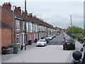
10
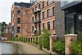
Canalside apartments by Nottingham Road
Modern apartments in converted hosiery mill.
Image: © David Martin
Taken: 25 Mar 2024
0.08 miles