IMAGES TAKEN NEAR TO
Pinfold Jetty, LOUGHBOROUGH, LE11 1BQ
Introduction
This page details the photographs taken nearby to Pinfold Jetty, LE11 1BQ by members of the Geograph project.
The Geograph project started in 2005 with the aim of publishing, organising and preserving representative images for every square kilometre of Great Britain, Ireland and the Isle of Man.

There are currently over 7.5m images from over14,400 individuals and you can help contribute to the project by visiting https://www.geograph.org.uk
Image Map
Images are licensed for reuse under creativecommons.org/licenses/by-sa/2.0
Notes
- Clicking on the map will re-center to the selected point.
- The higher the marker number, the further away the image location is from the centre of the postcode.
Image Listing (388 Images Found)
Images are licensed for reuse under creativecommons.org/licenses/by-sa/2.0
Image
Details
Distance
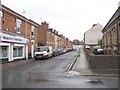
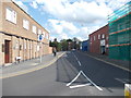
5
School Street
What looks like a fairly new gate at Jubilee Way.
Image: © Thomas Nugent
Taken: 8 Sep 2014
0.04 miles
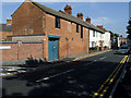
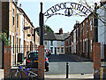
7
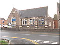
#25 Pinfold Gate
Former Warner Street School & Schoolhouse
Image: © Roger Templeman
Taken: 30 Sep 2015
0.04 miles
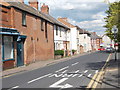
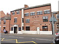
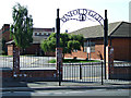
8
Pinfold Gate Day Nursery - Pinfold Gate
Image: © Betty Longbottom
Taken: 9 May 2012
0.04 miles
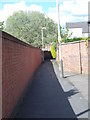
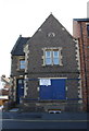
9
Pinfold Gate
The road is bisected by the new A6 Jubilee Way at this point.
Image: © Thomas Nugent
Taken: 8 Sep 2014
0.05 miles