IMAGES TAKEN NEAR TO
Gregory Street, LOUGHBOROUGH, LE11 1AS
Introduction
This page details the photographs taken nearby to Gregory Street, LE11 1AS by members of the Geograph project.
The Geograph project started in 2005 with the aim of publishing, organising and preserving representative images for every square kilometre of Great Britain, Ireland and the Isle of Man.

There are currently over 7.5m images from over14,400 individuals and you can help contribute to the project by visiting https://www.geograph.org.uk
Image Map (Loading...)


Getting Data...Please wait
Leaflet Map data © OpenStreetMap
Images are licensed for reuse under creativecommons.org/licenses/by-sa/2.0
Notes
- Clicking on the map will re-center to the selected point.
- The higher the marker number, the further away the image location is from the centre of the postcode.
Image Listing (325 Images Found)
Images are licensed for reuse under creativecommons.org/licenses/by-sa/2.0
Image
Details
Distance
1
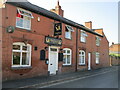
Peacock Inn, Factory Street, Loughborough
Showing site of Image on right hand frontage.
Image: © El Loco
Taken: 13 Aug 2022
0.03 miles
2
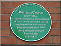
Plaque to William Cotton
On wall of Peacock Inn
Image: © El Loco
Taken: 13 Aug 2022
0.03 miles
3
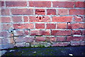
Benchmark on The Peacock Inn
Ordnance Survey cut mark benchmark described on the Bench Mark Database at http://www.bench-marks.org.uk/bm63394
Image: © Roger Templeman
Taken: 5 Jan 2015
0.03 miles
4
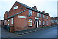
The Peacock Inn, Factory Street
There is an OS benchmark Image below the green CAFFREY'S sign
Image: © Roger Templeman
Taken: 5 Jan 2015
0.03 miles
6
Leicester Road, Loughborough, Leics.
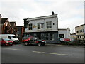
A view of The Royal Oak public house and row of shops, situated on one side the busy A6 road. It was taken from near a row of parking bays opposite that serve Southfields Park. Leicester Road was developed in the Georgian and early Victorian period as the town began to grow and it is still characterised by rows of three storey town houses. In the 1930s Leicester Road was classified as part of a section of a trunk road linking London and Inverness.Today it is still heavily used by local traffic and heavy goods vehicles despite the fact that the M1 has been the main traffic route through the county for several decades. The Royal Oak, an early 20th century pub with its sash windows intact, seems well maintained. The sweep of the road and the nature and character of the trees and buildings bordering the road have changed little over the years and because of this it has been included within the town’s conservation area.
Image: © David Hallam-Jones
Taken: 29 Sep 2016
0.04 miles

8
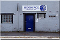
Moonface Brewery & Tap
This micro-brewery with its tap room is tucked away on Moira Street, just off Loughborough town centre. The bar opened in 2018 in a former warehouse building; brewing takes place in a room behind the bar.
Image: © Stephen McKay
Taken: 13 May 2022
0.07 miles
9
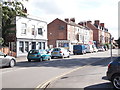
New King Street, Loughborough
At its junction with Great Central Road (right).
Image: © Richard Vince
Taken: 1 Sep 2012
0.08 miles
