IMAGES TAKEN NEAR TO
School Lane, HINCKLEY, LE10 3LH
Introduction
This page details the photographs taken nearby to School Lane, LE10 3LH by members of the Geograph project.
The Geograph project started in 2005 with the aim of publishing, organising and preserving representative images for every square kilometre of Great Britain, Ireland and the Isle of Man.

There are currently over 7.5m images from over14,400 individuals and you can help contribute to the project by visiting https://www.geograph.org.uk
Image Map
Images are licensed for reuse under creativecommons.org/licenses/by-sa/2.0
Notes
- Clicking on the map will re-center to the selected point.
- The higher the marker number, the further away the image location is from the centre of the postcode.
Image Listing (35 Images Found)
Images are licensed for reuse under creativecommons.org/licenses/by-sa/2.0
Image
Details
Distance
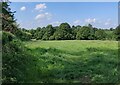
1
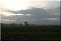
Wolvey Sunset
Wolvey, Listed in the Domesday Book of 1086 as Ulveia
Image: © Beryl Allcoat
Taken: 3 Apr 2008
0.05 miles
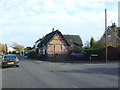
3
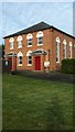
Wolvey Baptist Chapel
The Baptist Chapel in Wolvey, Warwickshire.
Image: © Peter Mackenzie
Taken: 6 Feb 2017
0.05 miles
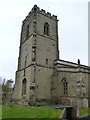
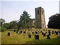
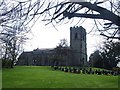
8
Gravestones at Saint John the Baptist church, Wolvey
Image: © Mat Fascione
Taken: 20 Sep 2019
0.08 miles
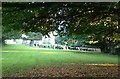
9
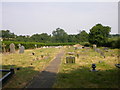
Wolvey Cemetery
East end of the village on Wolds Lane.
Image: © Ian Rob
Taken: 4 Jul 2006
0.09 miles
10
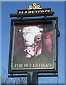
Sign for the Bulls Head public house, Wolvey
Image: © JThomas
Taken: 19 Nov 2016
0.09 miles