IMAGES TAKEN NEAR TO
Coal Pit Lane, HINCKLEY, LE10 3HD
Introduction
This page details the photographs taken nearby to Coal Pit Lane, LE10 3HD by members of the Geograph project.
The Geograph project started in 2005 with the aim of publishing, organising and preserving representative images for every square kilometre of Great Britain, Ireland and the Isle of Man.

There are currently over 7.5m images from over14,400 individuals and you can help contribute to the project by visiting https://www.geograph.org.uk
Image Map (Loading...)


Getting Data...Please wait
Leaflet Map data © OpenStreetMap
Images are licensed for reuse under creativecommons.org/licenses/by-sa/2.0
Notes
- Clicking on the map will re-center to the selected point.
- The higher the marker number, the further away the image location is from the centre of the postcode.
Image Listing (3 Images Found)
Images are licensed for reuse under creativecommons.org/licenses/by-sa/2.0
Image
Details
Distance
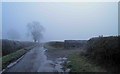
1
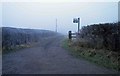
Farm Lane to Ashurst Farm near Wolvey
Image: © Steve Fareham
Taken: 12 Dec 2012
0.16 miles
3
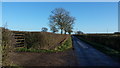
Coal Pit Lane in winter sunshine
Coal Pit Lane is a rural cul-de-sac leading to a couple of isolated farms. Here it is photographed on a frosty winter's morning.
Image: © Peter Mackenzie
Taken: 2 Jan 2017
0.18 miles