IMAGES TAKEN NEAR TO
Nuffield Road, HINCKLEY, LE10 3DG
Introduction
This page details the photographs taken nearby to Nuffield Road, LE10 3DG by members of the Geograph project.
The Geograph project started in 2005 with the aim of publishing, organising and preserving representative images for every square kilometre of Great Britain, Ireland and the Isle of Man.

There are currently over 7.5m images from over14,400 individuals and you can help contribute to the project by visiting https://www.geograph.org.uk
Image Map
Images are licensed for reuse under creativecommons.org/licenses/by-sa/2.0
Notes
- Clicking on the map will re-center to the selected point.
- The higher the marker number, the further away the image location is from the centre of the postcode.
Image Listing (14 Images Found)
Images are licensed for reuse under creativecommons.org/licenses/by-sa/2.0
Image
Details
Distance
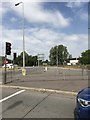
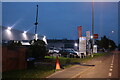
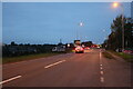
1
Road from industrial estate
The photograph shows the main entrance and exit route to the industrial estate on the western fringe of Hinckley.
Image: © Peter Mackenzie
Taken: 9 May 2017
0.11 miles
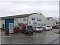
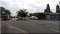
8
Watling Street at the Dodwells Roundabout
Image: © David Howard
Taken: 18 Oct 2020
0.22 miles
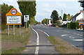
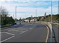
9
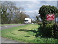
A5 west of Hinckley
The very busy A5 passes the gateway to Padge Hall Farm.
Image: © Stephen McKay
Taken: 1 May 2006
0.23 miles