IMAGES TAKEN NEAR TO
Field Close, HINCKLEY, LE10 3AZ
Introduction
This page details the photographs taken nearby to Field Close, LE10 3AZ by members of the Geograph project.
The Geograph project started in 2005 with the aim of publishing, organising and preserving representative images for every square kilometre of Great Britain, Ireland and the Isle of Man.

There are currently over 7.5m images from over14,400 individuals and you can help contribute to the project by visiting https://www.geograph.org.uk
Image Map
Images are licensed for reuse under creativecommons.org/licenses/by-sa/2.0
Notes
- Clicking on the map will re-center to the selected point.
- The higher the marker number, the further away the image location is from the centre of the postcode.
Image Listing (34 Images Found)
Images are licensed for reuse under creativecommons.org/licenses/by-sa/2.0
Image
Details
Distance
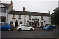
1

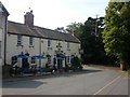
Wolvey village sign
At The Square, in the centre of the village.
Image: © Mat Fascione
Taken: 5 Jun 2014
0.07 miles
5
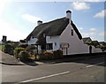
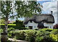
Wolvey-Coventry Road
Thatched Cottage on the corner of Bulkington Road.
Image: © Ian Rob
Taken: 25 Feb 2012
0.08 miles