IMAGES TAKEN NEAR TO
Lobelia Close, HINCKLEY, LE10 2UL
Introduction
This page details the photographs taken nearby to Lobelia Close, LE10 2UL by members of the Geograph project.
The Geograph project started in 2005 with the aim of publishing, organising and preserving representative images for every square kilometre of Great Britain, Ireland and the Isle of Man.

There are currently over 7.5m images from over14,400 individuals and you can help contribute to the project by visiting https://www.geograph.org.uk
Image Map (Loading...)


Getting Data...Please wait
Leaflet Map data © OpenStreetMap
Images are licensed for reuse under creativecommons.org/licenses/by-sa/2.0
Notes
- Clicking on the map will re-center to the selected point.
- The higher the marker number, the further away the image location is from the centre of the postcode.
Image Listing (19 Images Found)
Images are licensed for reuse under creativecommons.org/licenses/by-sa/2.0
Image
Details
Distance
1
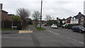
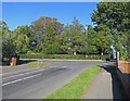
Road to Burbage
Azeala Drive meets the road to Burbage.
Image: © Peter Mackenzie
Taken: 21 Feb 2017
0.11 miles
2
Sketchley Road in Burbage, Leicestershire
At its corner with Azalea Drive.
Image: © Mat Fascione
Taken: 12 Jan 2008
0.12 miles
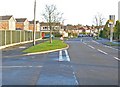
3
Cycle path
The cycle path adjacent to the B4109 heading south from Hinckley town centre.
Image: © Peter Mackenzie
Taken: 21 Feb 2017
0.16 miles
4
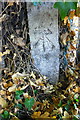
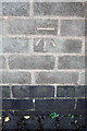
Benchmark on concrete post, Rugby Road
Ordnance Survey cut mark benchmark described on the Bench Mark Database at http://www.bench-marks.org.uk/bm70583
Image: © Roger Templeman
Taken: 1 Oct 2015
0.17 miles
5
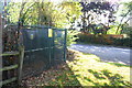
Electricity substation, Rugby Road
There is an OS benchmark Image on the concrete post at the corner of the substation enclosure at the left hand edge of the image
Image: © Roger Templeman
Taken: 1 Oct 2015
0.17 miles
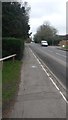
6
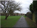
Path beside recreation ground, Sketchley Hill
Image: © JThomas
Taken: 25 Feb 2017
0.17 miles
8
Benchmark on wall between house and garage of #53 Greenwood Road
Ordnance Survey cut mark benchmark described on the Bench Mark Database at http://www.bench-marks.org.uk/bm70584
Image: © Roger Templeman
Taken: 1 Oct 2015
0.19 miles
10
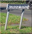
Aldridge Road sign east end north side
Image: © Andrew Tatlow
Taken: 27 Sep 2018
0.19 miles