IMAGES TAKEN NEAR TO
Coventry Road, HINCKLEY, LE10 2HW
Introduction
This page details the photographs taken nearby to Coventry Road, LE10 2HW by members of the Geograph project.
The Geograph project started in 2005 with the aim of publishing, organising and preserving representative images for every square kilometre of Great Britain, Ireland and the Isle of Man.

There are currently over 7.5m images from over14,400 individuals and you can help contribute to the project by visiting https://www.geograph.org.uk
Image Map
Images are licensed for reuse under creativecommons.org/licenses/by-sa/2.0
Notes
- Clicking on the map will re-center to the selected point.
- The higher the marker number, the further away the image location is from the centre of the postcode.
Image Listing (11 Images Found)
Images are licensed for reuse under creativecommons.org/licenses/by-sa/2.0
Image
Details
Distance
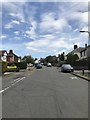
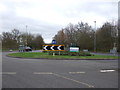
2
Approaching Three Pots Roundabout on Rugby Road (B4109)
Looking south east.
Image: © JThomas
Taken: 25 Feb 2017
0.14 miles
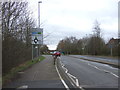
3
Roundabout on Rugby Road (B4109)
Looking south east.
Image: © JThomas
Taken: 25 Feb 2017
0.15 miles
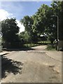
5
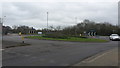
Roundabout
A roundabout manages the traffic flow on the B4109 on the outskirts of Hinckley.
Image: © Peter Mackenzie
Taken: 21 Feb 2017
0.17 miles
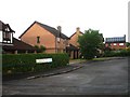
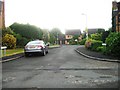
7
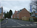
Sunloch Close, Burbage
New housing development off Three Pots Road.
Image: © JThomas
Taken: 25 Feb 2017
0.21 miles
8
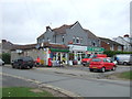
Sketchley Post Office
Showing position of postbox No. LE10 17.
Image: © JThomas
Taken: 25 Feb 2017
0.21 miles