IMAGES TAKEN NEAR TO
Coral Close, HINCKLEY, LE10 2HB
Introduction
This page details the photographs taken nearby to Coral Close, LE10 2HB by members of the Geograph project.
The Geograph project started in 2005 with the aim of publishing, organising and preserving representative images for every square kilometre of Great Britain, Ireland and the Isle of Man.

There are currently over 7.5m images from over14,400 individuals and you can help contribute to the project by visiting https://www.geograph.org.uk
Image Map (Loading...)


Getting Data...Please wait
Leaflet Map data © OpenStreetMap
Images are licensed for reuse under creativecommons.org/licenses/by-sa/2.0
Notes
- Clicking on the map will re-center to the selected point.
- The higher the marker number, the further away the image location is from the centre of the postcode.
Image Listing (7 Images Found)
Images are licensed for reuse under creativecommons.org/licenses/by-sa/2.0
Image
Details
Distance
5
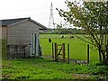
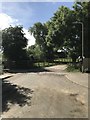
Horse Paddock near Burbage
These horses are kept in a field off Bullfurlong Lane, on the edge of the built-up area of Burbage.
Image: © Stephen McKay
Taken: 22 Oct 2006
0.17 miles
7
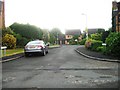
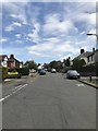
Sketchley Road in Burbage, Leicestershire
Image: © Mat Fascione
Taken: 12 Jan 2008
0.22 miles