IMAGES TAKEN NEAR TO
Frezenberg Close, HINCKLEY, LE10 2FL
Introduction
This page details the photographs taken nearby to Frezenberg Close, LE10 2FL by members of the Geograph project.
The Geograph project started in 2005 with the aim of publishing, organising and preserving representative images for every square kilometre of Great Britain, Ireland and the Isle of Man.

There are currently over 7.5m images from over14,400 individuals and you can help contribute to the project by visiting https://www.geograph.org.uk
Image Map (Loading...)


Getting Data...Please wait
Leaflet Map data © OpenStreetMap
Images are licensed for reuse under creativecommons.org/licenses/by-sa/2.0
Notes
- Clicking on the map will re-center to the selected point.
- The higher the marker number, the further away the image location is from the centre of the postcode.
Image Listing (16 Images Found)
Images are licensed for reuse under creativecommons.org/licenses/by-sa/2.0
Image
Details
Distance
1
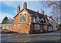
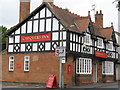
Chequers Inn, Burbage
A public house on Lutterworth Road in Burbage, Leicestershire.
Image: © Mat Fascione
Taken: 12 Jan 2008
0.11 miles
2
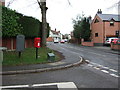
Lutterworth Road, Burbage
Showing position of Postbox No. LE10 10.
See Image] for postbox.
Image: © JThomas
Taken: 25 Feb 2017
0.12 miles
3
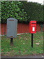
Elizabeth II postbox on Lutterworth Road, Burbage
Image: © JThomas
Taken: 25 Feb 2017
0.12 miles
4
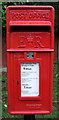
Close up, Elizabeth II postbox on Lutterworth Road, Burbage
Postbox No. LE10 10.
See Image] for wider view.
Image: © JThomas
Taken: 25 Feb 2017
0.12 miles
5
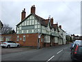
Burbage Chequers Inn
Charles Wells brewery pub on Lutterworth Road
Image: © the bitterman
Taken: 3 Aug 2010
0.12 miles
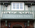
6
Chequers Inn, Burbage
On Lutterworth Road (B578).
Image: © JThomas
Taken: 25 Feb 2017
0.12 miles

10
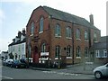
Burbage Congregational Church
In Church Street, dates from 1895.
Image: © Ian Rob
Taken: 2 Mar 2011
0.19 miles