IMAGES TAKEN NEAR TO
Ashburton Close, HINCKLEY, LE10 2EW
Introduction
This page details the photographs taken nearby to Ashburton Close, LE10 2EW by members of the Geograph project.
The Geograph project started in 2005 with the aim of publishing, organising and preserving representative images for every square kilometre of Great Britain, Ireland and the Isle of Man.

There are currently over 7.5m images from over14,400 individuals and you can help contribute to the project by visiting https://www.geograph.org.uk
Image Map (Loading...)


Getting Data...Please wait
Leaflet Map data © OpenStreetMap
Images are licensed for reuse under creativecommons.org/licenses/by-sa/2.0
Notes
- Clicking on the map will re-center to the selected point.
- The higher the marker number, the further away the image location is from the centre of the postcode.
Image Listing (11 Images Found)
Images are licensed for reuse under creativecommons.org/licenses/by-sa/2.0
Image
Details
Distance
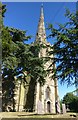
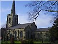
2
Burbage church
The church viewed from a distance.
Image: © Peter Mackenzie
Taken: 2 Jan 2018
0.16 miles
3
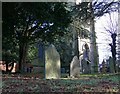
St Catherine's Church and graveyard, Burbage
Image: © Mat Fascione
Taken: 12 Jan 2008
0.17 miles
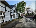
5
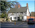
House on Church Street, Burbage
Next door to St Catherine's Church.
Image: © Mat Fascione
Taken: 12 Jan 2008
0.18 miles
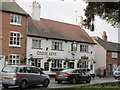
7
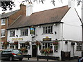
Burbage Cross Keys
Marstons pub close to the village church.
Image: © the bitterman
Taken: 3 Aug 2010
0.18 miles
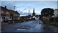
10
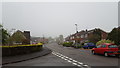
Suburban homes
A private housing development on the east side of Hinckley.
Image: © Peter Mackenzie
Taken: 25 May 2018
0.21 miles