IMAGES TAKEN NEAR TO
Maizefield, HINCKLEY, LE10 1YF
Introduction
This page details the photographs taken nearby to Maizefield, LE10 1YF by members of the Geograph project.
The Geograph project started in 2005 with the aim of publishing, organising and preserving representative images for every square kilometre of Great Britain, Ireland and the Isle of Man.

There are currently over 7.5m images from over14,400 individuals and you can help contribute to the project by visiting https://www.geograph.org.uk
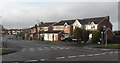
Image Map (Loading...)


Getting Data...Please wait
Leaflet Map data © OpenStreetMap
Images are licensed for reuse under creativecommons.org/licenses/by-sa/2.0
Notes
- Clicking on the map will re-center to the selected point.
- The higher the marker number, the further away the image location is from the centre of the postcode.
Image Listing (11 Images Found)
Images are licensed for reuse under creativecommons.org/licenses/by-sa/2.0
Image
Details
Distance
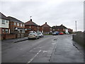
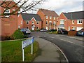
2
Hardy Close, Hinckley
Residential housing in the north of the town.
Image: © Peter Mackenzie
Taken: 18 Jun 2018
0.16 miles
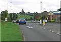
6
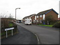
Tudor Road, Hinckley
Looking south west on a rainy winter's day.
Image: © JThomas
Taken: 25 Feb 2017
0.22 miles
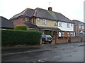
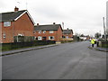
7
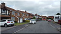
Netherley Road, Hinckley
Modern housing in the northern suburbs of Hinckley.
Image: © Stephen McKay
Taken: 3 Dec 2006
0.22 miles
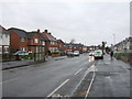
8
Netherley Road, Hinckley
Taken from the junction with Middlefield Place.
Image: © Peter Whatley
Taken: 11 Dec 2008
0.23 miles