IMAGES TAKEN NEAR TO
Kingston Drive, HINCKLEY, LE10 1TX
Introduction
This page details the photographs taken nearby to Kingston Drive, LE10 1TX by members of the Geograph project.
The Geograph project started in 2005 with the aim of publishing, organising and preserving representative images for every square kilometre of Great Britain, Ireland and the Isle of Man.

There are currently over 7.5m images from over14,400 individuals and you can help contribute to the project by visiting https://www.geograph.org.uk
Image Map (Loading...)


Getting Data...Please wait
Leaflet Map data © OpenStreetMap
Images are licensed for reuse under creativecommons.org/licenses/by-sa/2.0
Notes
- Clicking on the map will re-center to the selected point.
- The higher the marker number, the further away the image location is from the centre of the postcode.
Image Listing (10 Images Found)
Images are licensed for reuse under creativecommons.org/licenses/by-sa/2.0
Image
Details
Distance
1
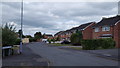
Blenheim Close, Hinckley
A residential cul-de-sac in the north of the town.
Image: © Peter Mackenzie
Taken: 18 Jun 2018
0.10 miles
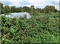
2
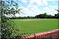
Cricket Match in progress
Cricket Match in progress,Swallows Green Recreation Ground,Harwood drive,off Barwell Lane.
Image: © Roy William Shakespeare
Taken: 8 Jul 2007
0.14 miles
3
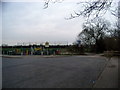
Swallows Green, Barwell Lane, Hinckley
The image shows the newly opened play area for children under 8 years.
Also shown,on the left of the picture is the entrance to the pathway, leading to Barwell, which is part of the National/Regional Cycle network.
Image: © Roy William Shakespeare
Taken: 15 Mar 2007
0.14 miles
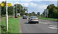
7
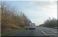
Allotments along the A47
On the northern edge of Hinckley.
Image: © Mat Fascione
Taken: 13 Sep 2008
0.20 miles
8
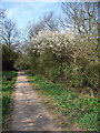
Footpath to Barwell
Part of the footpath from Swallows Green, Hinckley to Barwell.
Image: © Roy William Shakespeare
Taken: 8 Apr 2007
0.22 miles
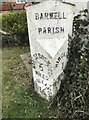
9
Old Milepost by the B4667, Ashby Road, Hinckley
Cast iron post by the B4667 (was A447), in parish of HINCKLEY (HINCKLEY AND BOSWORTH District), by No. 240 Ashby Road, just South of junction with Normandy Way (A47), between path and fence, on West side of road. Cort Paul iron casting, erected by the Hinckley & Melbourne turnpike trust in the 19th century.
Inscription reads:-
: MARKET BOSWORTH / 6 / MILES / ASHBY-DE-LA-ZOUCH / 16 / MILES : : BARWELL / PARISH : : HINCKLEY / 1 / MILE :
Maker:-
: CORT PAUL / SCORNICK / LEICESTER :
Milestone Society National ID: LE_HKBH01.
Image: © J Higgins
Taken: 1 Nov 2004
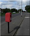
0.22 miles
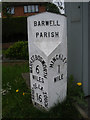
10
Old Milepost by the B4667, Ashby Road, Hinckley
Cast iron post by the B4667 (was A447), in parish of HINCKLEY (HINCKLEY AND BOSWORTH District), by No. 240 Ashby Road, just South of junction with Normandy Way (A47), between path and fence, on West side of road. Cort Paul iron casting, erected by the Hinckley & Melbourne turnpike trust in the 19th century.
Inscription reads:-
: MARKET BOSWORTH / 6 / MILES / ASHBY-DE-LA-ZOUCH / 16 / MILES : : BARWELL / PARISH : : HINCKLEY / 1 / MILE :
Maker:-
: CORT PAUL / SCORNICK / LEICESTER :
Milestone Society National ID: LE_HKBH01.
Image: © Brian Coleman
Taken: 3 May 2024
0.22 miles