IMAGES TAKEN NEAR TO
Leicester Road, HINCKLEY, LE10 1LT
Introduction
This page details the photographs taken nearby to Leicester Road, LE10 1LT by members of the Geograph project.
The Geograph project started in 2005 with the aim of publishing, organising and preserving representative images for every square kilometre of Great Britain, Ireland and the Isle of Man.

There are currently over 7.5m images from over14,400 individuals and you can help contribute to the project by visiting https://www.geograph.org.uk
Image Map (Loading...)


Getting Data...Please wait
Leaflet Map data © OpenStreetMap
Images are licensed for reuse under creativecommons.org/licenses/by-sa/2.0
Notes
- Clicking on the map will re-center to the selected point.
- The higher the marker number, the further away the image location is from the centre of the postcode.
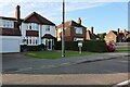
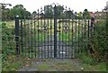
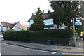
Image Listing (12 Images Found)
Images are licensed for reuse under creativecommons.org/licenses/by-sa/2.0
Image
Details
Distance
1
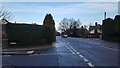
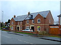
Arterial route out of Hinckley
One of the routes leaving Hinckley for Burbage.
Image: © Peter Mackenzie
Taken: 2 Jan 2018
0.03 miles
7
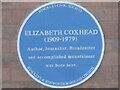
Plaque to Elizabeth Coxhead
On front of Hinckley Parks Primary School
Image: © El Loco
Taken: 18 Sep 2021
0.20 miles
8
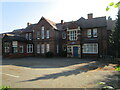
Hinckley Parks Primary School
Showing location of plaque Image
Image: © El Loco
Taken: 18 Sep 2021
0.20 miles